Author: Alexander Cui

Town of Mount Royal, Quebec, Canada

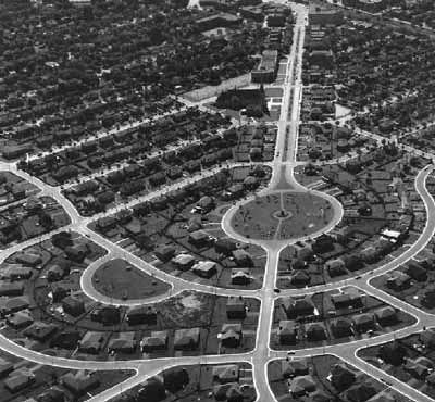
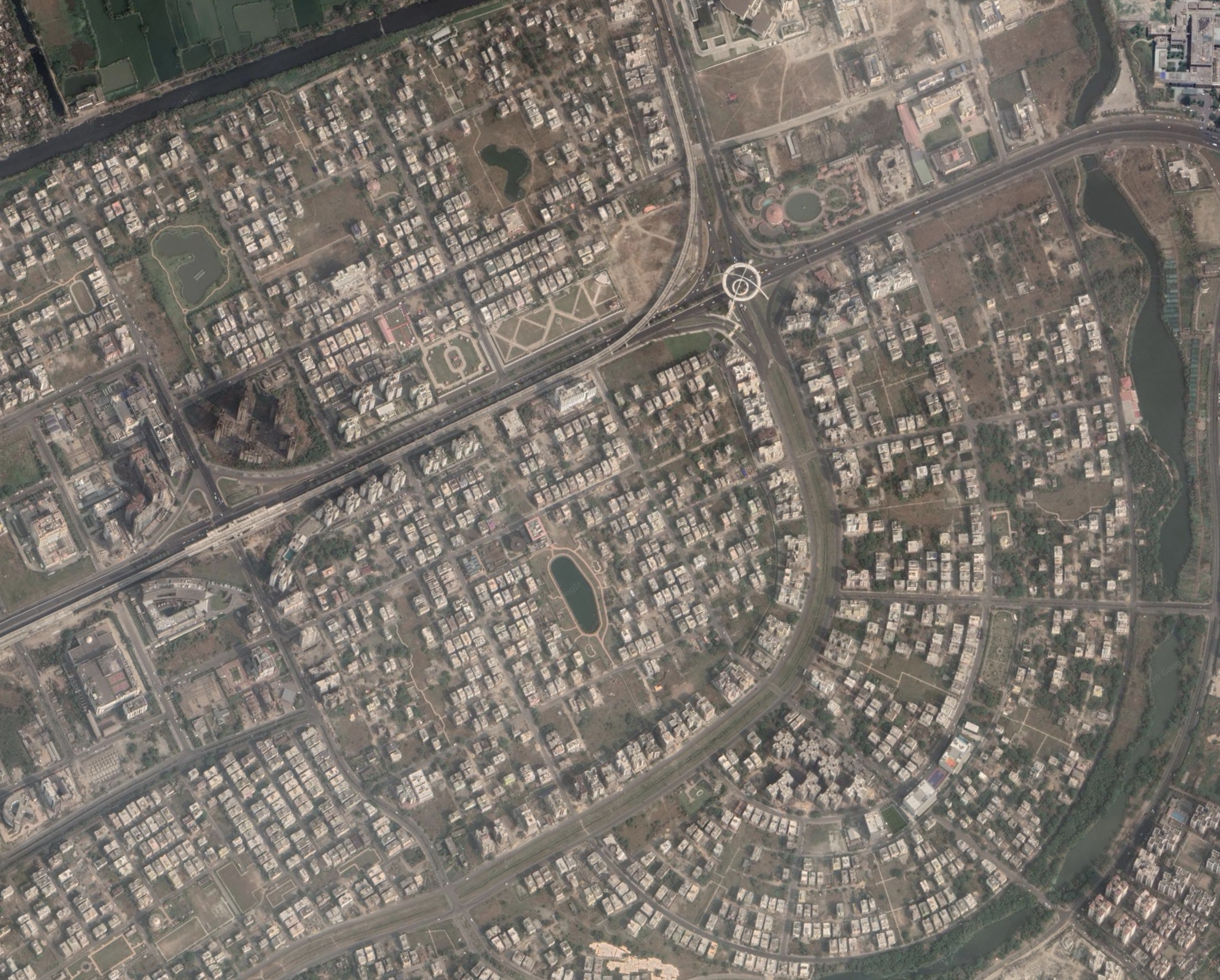
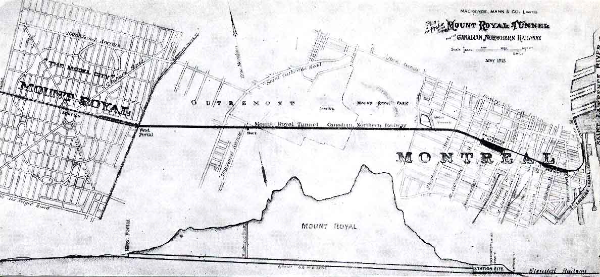
The Town of Mount Royal was a town founded in 1912 and designed by Frederick Todd, who was himself inspired by Ebenezer Howard and the Garden City movement. While currently a suburb surrounded by the city of Montreal, it was initially a Garden City separated from old Montreal by a greenbelt, and connected by an underground railway. Interestingly, while the land was purchased from farmland, the main proceeds of sales were used to fund the expansion of the Canadian railway instead of community re-investment. This community was made for upper-income residents, avoiding the original spirit of Howard’s city. From the layout, it’s central square bares a resemblance to Letchworth’s oval center with radial roads emanating outwards. Some unique designs that embody the philosophy of Garden Cities include curved roads and parks in roundabouts break up the grid and create neighbourhood-sized communities, while a circular road encompassing the inner half of the town offers easy passage between neighbourhoods.

Mount Royal, Quebec

Mount Royal, Quebec was a model city designed to be at the foot of Mount Royal mountain in Canada. Designed in 1912, Mount Royal was created as a response to industrialization and big-city problems that plagued large metropolitan centers during the late 19th and early 20th centuries and was an alternative to urban renewal movements of the times. As a  Garden City,  Montreal large green spaces, the presence of a railway, main arterial roads, winding parkways, and was surrounded by a large rural belt. However, besides design elements, the city failed to realize the spirit of Ebenezer Howard’s goals for Garden Cities, creating an enclave for upper-class citizens instead. Additionally, after the Canadian Northern Railway tunnel projects reached completion, the city lacked industry and self-sufficiency, relying more on rapid transit systems to the opportunities in downtown Montreal.

The garden city has changed little, socially and structurally, from its 1912 creation, but the town is currently facing pressure to rezone and change height restrictions in order to make room for taller condos and additional housing.

Den-en-chōfu, Japan

Den-en-chōfu, is a district in southern Tokyo, 10km away from the Tokyo center. It was initially designed in the early 19th centuries and was heavily inspired by Ebenezer’s Garden city concept. Public facilities such as subway station, hospital, post office and school are all concentrated in the middle of the circular road pattern. This allows its residents to be in close proximities to the essential facilities while being free of the noise and busy life style. The district features many parks, wide road networks with lots of cherry trees. Its unique design and town-feels have made it a popular district among executives and celebrities.

Reston, VA, USA

Reston, VA is a Garden City that was developed in the 1960s.  The city’s design is heavily inspired by Garden City principles, and was designed to theoretically be a Garden City to nearby Washington, DC. The city is split by superblocks surrounded by large roads with cul-de-sacs within, and a large greenbelt of rural farmland surrounds the city. Reston also has districts separated by use, and countless footpaths that cut through the city’s many parks. Yet despite these elements, the city fails as a Garden City. The city is incredibly autocentric and relies heavily on nearby DC for jobs, education, and entertainment; in addition, the city is socioeconomically homogeneous. Reston is proof that picking and choosing elements of a Green City does not necessarily create a Garden City.

Pinelands, Cape Town

Pinelands, South Africa’s first garden city, was created in response to the 1918 Influenza and the overcrowding that resulted in many deaths. Inspired by Ebenezer Howard, designer Richard Stuttaford envisioned a suburb of Cape Town that would grant the affluent members of the city the ability to live among the amenities of a major city and the beauty of the environment. These inhabitants have access to over 30 parks within the city limits as well as a view of Tabletop Mountain, and very few man-made structures exceed 4 stories. In Pinelands, Stuttaford managed to construct better houses and public buildings while also nurturing the education of equality by providing high-quality school halls to address the decades of racial inequality in South Africa. 

Eco Village, New York

Founded in 1991, Eco Village outside Ithaca, New York now houses about 240 people in dense housing structures. The founders bought the land in the area, and they grow their own food, which they use to sustain themselves in an environmentally-friendly way. They have a partnership with Cornell University, and they give regular tours to university students and others to educate the public on living sustainably. Homes are duplexes, and cars are parked in a central parking lot, rather than close to homes, and laundry is located in one of the two large common buildings. Everyone who moves in takes part in a learning process so that they can decide whether they want to stay: because it’s community-centered, all decisions are made by the community together, and everyone is expected to clean around the area. Many residents have home-based businesses inside the Eco Village, like a massage therapist, a counselor, computer consultants, an attorney, and more.

Forest Hills, NY

Forest Hills, located in greater Queens NY, is one of America’s oldest planned communities modeled after England’s garden cities. For the most part it was successful because it incorporates a shared green space with urban conveniences, is overseen by the Forest Hills Garden Corporation which thereby forms a strong sense of community, easy transportation via subways and the Long Island Rail Road to the city and the characteristic street design such as the repeated use of cul-de-sacs and housing blocks. However, Forest Hills no longer provides affordable housing for blue-collar workers- instead it offers one of the most expensive residential properties in Queens County.

Canberra, Australia

Canberra was founded in 1913 as an entirely planned city and was built from scratch to be Australia’s capital. Incorporating elements of the Prairie School and Garden City movement into the design of the Parliament Triangle, the city also boasts a number of planned amenities like curved boulevards, an abundance of park space, and a man made reservoir. In recent years it has been criticized for contributing to urban sprawl and having a layout that is not designed for walking. Its distinct separation of residential, industrial, and civic districts has only furthered urban sprawl and made it difficult for residents to go anywhere without the use of a car or public transportation. Many of Canberra’s issues likely result from its lack of diverse economic opportunities and unplanned suburban additions. Recently, it has also been susceptible to the effects of climate change.

Quezon City, Philippines

Quezon City, created in 1939, is a city in Metro Manila and was originally intended as a capital complex. Some of its original features are heavily inspired by the garden city movement. The city was planned to be a self-contained city, organized radially around a central green, with wards divided by large boulevards, generous communal green spaces peppered throughout, and the presence of greenbelts. Notably, the site has since evolved from a self-contained capital inspired by the garden city movement to something that, today, has been subsumed the wider Metro Manila, becoming extremely dense in the process. In its current form, it suggests that the self-containment principle is merely an ideal, one which, in this case, did not hold against the sprawl of the adjacent cities. In its original form, even if it probably would not have been read as a garden city by Howard in its totality, the presence of these design features are a testament to the internationality of the garden city movement.

Coober Pedy

Coober Pedy is a small, isolated, desert community in South Australia that was established in 1916 after the gemstone opal was found in surrounding mines. An “opal rush” caused foreigners and native Australian’s alike to flock to this area in order to seek riches. However, the area prior to 1916 was inhabited solely by aboriginal populations, due to the intense heat and sun exposure in the region. In order to cope with the harsh climate, the migrating miners decided to build their homes and institutions in the one place where they could find shade: underground. The entire town has roughly 2500 inhabitants and much of their infrastructure, outside of the main roads that connect them with the outside world, is underground. There is a myriad of tunnels that connect churches, townhouses, stores, tourist attractions, restaurants, and other amenities. The personality of the inhabitants is very neighborly due to the close proximity and the intense work that it takes to settle in Coober Pedy. Teamwork has allowed the people in this community to thrive in a very inhospitable place. Furthermore, the dynamic of the town allows the dwellers to find tight-knit community relations.

Pinawa

The community of Pinawa was first developed to support the construction/operation of a hydroelectric generating plant. It ran until 1951, and the original site is now a heritage park. Present day, the community is located south of the original site, but was still created for the purpose of a research facility, i.e., for the purpose of some company. For most of it’s lifetime, the community was solely based on its ability to support whatever project was providing employment opportunities and even housing.

Eureka Springs, Arkansas

Eureka Springs, Arkansas was incorporated as a city in 1880 after it gained
widespread public appeal from its hot springs that were rumored to have magical healing properties. The springs acted as both an economic and physical focal point for the city. Settlements concentrated around the number of hot springs in the area and the structures
(primarily shanties and tents) were built for immediate occupancy and valued by their accessibility to the springs. Eureka Springs serves as an intriguing example of how cities can experience rapid economic growth and popularity through a public attraction–
and how that attraction can also have an influence on the physical environment and layout of the city.

Cyberjaya, Malaysia

Cyberjaya, Malaysia is a planned city home to multiple universities and hi-tech corporations. Pitched to the government as a Malaysian Silicon Valley, Cyberjaya is the centerpiece of MSC Malaysia, a special economic zone meant to catalyze Malaysia’s transformation into a “new knowledge economy.” It is an example of a new city designed to fulfill an specific economic and social purpose, and its design reflects that purpose, with housing developments like Neo Cyber and Taman Pinggiran Cyber on the periphery of Multimedia University and Cyberjaya’s two business districts.

Source: https://www.cyberjayamalaysia.com.my/
Image Source: Google Earth

New Town, Kolkata, India

New Town, India, was developed in the 1990s by the state government of West Bengal to cater to the rising middle class population and to develop a brand new technology hub. While the city has been hailed as a ‘Solar City’ due to its planned sustainable, and high-tech infrastructure, it has also garnered criticisms due to the displacement of farmers, street vendors and laborers from its fertile lands. The city demonstrates a tension between India’s working class and white collar workers as they share space, and the government’s vision and the reality when developing new cities in India.

Quebec City

Quebec City is the capital of the Quebec province in Canada. Settled by the French in 1608, it is the only North American city still with fortified walls north of Mexico. It shows an example of the Greek Grid – with its grid adapting to the hilly geography of the coast and peninsula. The city is built with the example of a French “ville” as opposed to a more centralized new city, and was originally divided into an upper city made for the elite and lower city for merchants and artisans.

Twin Falls, Idaho

Twin Falls, Idaho is a coastal city in the Magic Valley region in south-central Idaho. Incorporated in 1905, it is the regional commercial center for south-central Idaho and northeastern Nevada. Its origins lie in the Twin Falls Land and Water Company, which was created to build an irrigation canal system for the area. Although planning was sparked by the company, the town was a comprehensively planned community, designed by celebrated architect Emmanual Louis Masqueray after previously failed drawings.  The original townsite follows northeast-to-southwest and northwest-to-southeast roads, unique design, as a way to allow the sun to come into every room in the home at some point during the day.

However, it’s initial layout and design continued to evolve after Masqueray’s planning – the later expansion of the town ignored Masqueray’s careful planning, forgoing his unique designs for north-south and east-west streets. This juxtaposition emphasizes the original layout’s unique and valuable qualities with the cardinal design implemented by later town planners.

Kyoto, Japan

Kyoto, Japan was built in 794 as the new capital of Japan. The city’s famous grid layout is reflective of the Emperor’s desire to centralize power – the Emperor’s palace, from which most major roads originated, functioned as the political and social heart of the city, and governmental institutions were clustered around the palace district. In modern times, the city’s center has shifted away from the palace, and the large, rigid grid is broken up into smaller alley roads. However, the historical city center still maintains the original grid and continues to be the heart of traditional culture in Kyoto.

Riverside Plaza, Minneapolis, MN

Riverside Plaza is a housing complex in Minneapolis that encompasses 11 buildings, 5,000 residents, and 1,300 units. It was developed as part of the New Town-in-Town movement from the U.S. Department of Housing and Urban Development in the 1970s. Because Riverside Plaza is just a housing complex, we have to wonder why it was classified as a “new town,” lacking a lot of quintessential city attributes like businesses where residents work. It was developed with the vision of being a self-sufficient, densely-populated urban area that catered to multiple income levels. However, its development has been controversial, as its developers “shunned community input, bought and razed homes and historical structures and were accused of coercing residents and business owners to sell out and get out.” More recently, it has been referred to as the “Ghetto in the Sky,” “Non-Reading Rainbow,” “Little Mogadishu,” and “Crack Stacks,” partly because of its association with lower-income Northeast African immigrants. Some residents say the density of the buildings and its apartment units has helped to foster a strong sense of community, despite and perhaps related to these epithets. 

Image source: http://digitours.augsburg.edu/items/show/15?tour=1&index=10

Brasilía, Brazil

Brasilia was founded in 1960, replacing Rio de Janeiro as the capital of Brazil. It was built with the intention of bringing further progress and urbanization into the interior while also relieving pressure from the overpopulated Atlantic coast. Brasilía was designed with residential, administrative, and monumental purpose in mind, and it separated itself from the slums, the baroque and classical architecture, and the colonial legacy of Rio de Janeiro. Designers’ use of urban planning, new roads, and futuristic architecture has been recognized as a fresh start by Brazilians. However, it was built to fit a smaller population than it holds now and was not designed with pedestrians in mind, so it is congested and environmentally unfriendly. Brasilía is coherent but lacks shops, street life, markets, and a sense of day-to-day life since it was built for civil service and the government.

Songdo, South Korea

Songdo, South Korea, a high tech business district, is an example of an aerotropolis: the city was built around an airport. It is also one of the world’s smartest cities with its high end technology surveilling the city. Arranged in a grid form, it was built with the goal of being an international business hub and eliminating problems like pollution. Sustainability was at the core of the city’s development, and it had over 40% of the city being park spaces, areas for urban farming, heavy public transit usage, and an advanced underground trash system. The biggest drawback of Songdo continues to be the difficulty to interact with other people, as the city is severely underpopulated.

The Villages

The Villages is an age-restricted CDP located in Central Florida. Since its creation in 1983, the population has swelled to over 120,000 and between 2010-2019 about 25,000 new homes were constructed. The sense of community, impressive array of amenities, and fairly robust housing stock have made it America’s most popular retirement destination and largest private development. While currently held as an industry model in the growing retirement market, The Villages nonetheless faces legitimate questions regarding urban sprawl, the health of its community, legislative oversight, and the implications of its age restrictions.

Henry Hudson Parkway

The Henry Hudson Parkway was one of the earliest built examples of the “20th century landscape vision” to “bring the county to town” by erasing the lines delineating urban and natural spaces. Robert Moses couched the expressway core of the Henry Hudson in a thick band of trees and greenspace, named “Riverside Park.”

Naples, Long Beach, California

Naples is a neighborhood in the city of Long Beach, CA, constructed to resemble an Italian resort village, with canals and gondola rides. In the center of the island is La Bella Fontana Park, a well-known meeting place and central focus.

Lusaka, Zambia

Lusaka, Zambia was intended as a garden city in sub-Saharan Africa. The 1931 plan segregated European and African communities, while offering very little in the form of economic activities. The divide can be seen from above even today and is accentuated by the greater amount of green space in the formerly European area.

Theme: Overlay by Kaira