Category: Neighborhood Units

Priestwood, Bracknell, England

Priestwood is a neighborhood unit of Bracknell, one of the 10 British new towns built in the 1940s after World War II. Planned for a size of 287 acres and a population of 7800 residents, with a primary school at the center and an eponymous avenue serving as a boundary, it hewed very closely to Clarence Perry’s original concept. Although Bracknell has undergone substantial redevelopment, the original neighborhood units have been preserved, with redevelopment focused on the city center. However, the redevelopment has accentuated one of the criticisms of the neighborhood unit concept: Priestwood is now both aesthetically and functionally isolated from the rest of the town.

the Mission District, San Francisco, California

The Mission distinct is a prominent neighborhood in San Francisco, California. It is relatively large, at 1.5 square miles and 45,000 residents. Before the 1940s, the neighborhood was largely composed of Irish and German immigrant workers in the working class. In the 1940s to 1960s, many Mexican immigrants were forced to move due to the construction of the Bay Bridge, and settled in the area, while led to white flight and the modern Mission’s Chicano/Latino character. Starting in the 1960s, the LGBTQ population in the Mission grew to be one of the most visible in the US. To me, the MIssion is a really fascinating example of a community that carries a huge amount of cultural and socio-economic diversity, while being united in an identity of alternativeness while the MIssion as their refuge. That concentration of cultures has led to the mission being an epicentre for arts, music, food and festivals. Between 1967-1973, the Mission Coalition Organization (MCO), a multi-issue community organization, also formed in the model set by Saul Alinsky. While the group split apart, it involved 20% of the 50,000 residents at its peak and left many neighborhood organizations that operate to this day, showing the potential of strong neighborhood identity coupled with active representation.

Fair Oaks, CA

Fair Oaks, CA

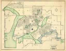
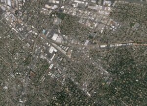
Fair Oaks is a neighborhood on the southeastern side of Redwood City, CA. In an almost completely suburban environment, Fair Oaks stands out as a well defined neighborhood, featuring community connection, a generally well defined extent (above the arterial on the bottom, left of the trees, and straddling the fork in the train tracks), and political power within the broader city. It is primarily Mexican-immigrant neighborhood, with many first and second generation families living there and giving the area a distinct character. Though decidedly larger in population than Clarence Perry’s vision, it’s still a cohesive neighborhood despite being split up by railroad lines. It seems that these rail lines act more as seams than barriers. Its self sufficiency comes from numerous services within its boundaries, ranging from locally-owned grocery stores to auto repair and more. Recently, the community has succeeded in attracting more public investment from the City relating to infrastructure and social services. The nexus of the community is the Fair Oaks community center, which is near one of the rail lines, and provides a hub of activities for local residents. The area also has a good number of schools, religious centers that represent the local population, and decent access to downtown. Perhaps the only area of improvement for this neighborhood is economic diversity, as despite being in the Bay Area it is relatively low-income. The trick would be creating a better income mix, while avoiding gentrification (which, in the Bay, is very tricky). Other than that, it’s a shining example of organic neighborhood growth that the city has only come to appreciate in the last ten years.

Baldwin Hills, Los Angeles

Baldwin Hills, Los Angeles, is a famous planned neighborhood unit by Clarence Stein, a pioneer in the application of Clarence Perry’s principles. Stein implemented a confined -known boundary- insular 80-acre super block with innovative, spacious, light-filled condominium units and plenty of green space that gives Baldwin Hills a distinct image. He prioritized pedestrian walkways within the public space, thus there are no major roads or highways that pass through, but there is nearby public transportation. The major streets bound the outskirts of the neighborhood, while Baldwin Hills itself has schools, malls, and family recreational activities that help it to form a sense of community and opportunities for residents to be active in the neighborhood.

Kanda, Tokyo, Japan

Kanda is a high-density, mixed-building neighborhood in Tokyo, Japan that is characterized by universities, residential areas, shrines and commercial centers like Akhibara, a famous electronics and anime hub. Kanda was built using the Japanese idea of ‘machi’, or neighborhood, and has a unique identity due to the high population of students and its electronics culture. Kanda is embedded within Tokyo, and like Perry’s original plans for neighborhood units, contains access to socialization, nature and civic services within walking distance, along with its own neighborhood identity and civic spaces in its bounded quadrilateral space. Where it differs from Perry’s ideas, and many neighborhood units in the West, is its density, its heterogenous building types, and the placement of roads instead of a community center at the center of the neighborhood. Kanda demonstrates the idea of a successfully adapted neighborhood unit integrated into a populated city, bringing a sense of community and convenience to an urban setting.

Väike-Oismäe

Väike-Õismäe is an Estonian neighborhood build in the 1970s. Väike-Oismäe is built in the fashion of Soviet microrayons, which allowed architects to plan rapidly developing urban complexes more efficiently for the purpose of creating collective societies. Residents were usually provided with free rooms or flats. Due to the high building costs of such «free» complexes, microrayons were often grouped into larger urban zones. Thus, Väike-Õismäe actually consists of several microrayons and has a population of 27,481. Microrayons provided only absolutely necessary facilities (kindergartens, grocery shops), but all other services were shared by the bigger residential areas. Such merging was accompanied by the reduction of the apartment buildings’ quality, creating homogeneous grey masses of panel-blocks all over the Soviet Union.

Rinkeby, Stockholm, Sweden

Rinkeby is a neighborhood in Stockholm, Sweden that was part of the Million Program, the public housing program implemented in Sweden in 1965 to make sure everyone could have a home in a neighborhood community at a reasonable price. Rinkeby and other neighborhoods in the program were implemented as a way to decrease the population density due to Stockholm’s urban congestion. Larger than Perry’s conception of a neighborhood at 19,000 inhabitants in 2016, it is an expanded neighborhood focused on providing social facilities and services, as seen in its range of schools, public spaces, libraries, and meeting places.

An attempt to address social segregation issues raised by neighborhood units, it’s principal aim was to mix and integrate different groups of immigrant households through the spatial mixing of tenures. However, its failure is an example of the issues raised with using neighborhoods as the basis for public housing projects – Rinkeby is isolated and cut off from other neighborhoods, an island of crime and breeze-block flats.

Caoyang New Village, Shanghai

Located in the Putuo District of Shanghai, Caoyang New Village was established in 1951 as one of China’s first implementations of the neighborhood unit. It grew out of increased demand for improved homes for the working and lower class— which was a principal concern of the Communist government at the time. Unlike most neighborhoods that tend to target the upper/middle class, the Caoyang New village was designed to house lower class citizens. However, it still paid close attention to its design and incorporated schools, social facilities, and vegetated areas into its plan. Unfortunately in the years following, new additions to Caoyang New Village were done hastily and were poorly constructed which ultimately resulted in many of the buildings needing to be taken down. What resulted from this was an assortment of buildings with varying sizes and construction styles— many of which are unable to be remodeled after it was named a heritage site in 2017. This currently remains one of the neighborhood’s biggest challenges as it is effectively frozen in time inside the rapidly modernizing city of Shanghai.

Greendale, WI

Greendale, Wisconsin was built as part of FDR’s “Greenbelt” project in the 1930s. It was built as a suburb of Milwaukee, for the purpose of housing its residents and to create construction jobs in the Great Depression. They built it on farmland, and preserved part of it as an actual “greenbelt” separating the community from downtown Milwaukee, partly so that residents would shop in their own community rather than walk to Milwaukee proper. Most of the units were single-family homes with 2-3 bedrooms and a garden space. The original plan wanted to build and sell 3,000 units, but by 1939, they only had 572 units. This meant that each unit was priced higher than originally planned for. Because of these high prices, and the fact that planners did not sell to Black people or families where both spouses worked, the population was very homogeneous, and definitely not lower-class. We can see how it adheres to Perry’s original plans, with each small subdivision of the neighborhood centered at least in part on an important building, like schools.

Hell’s Kitchen, Manhattan (New York)

Hell’s Kitchen is located on the west side of Manhattan. In the early 20th century, the area was run by local Irish gangs, populating the area with working-class Irish Americans. In the late 20th century, widespread gentrification changed the demographics of the neighborhood and ended the gang control. Currently, the area is home to a large portion of New York’s entertainment industry (i.e. CBS, The Daily Show, etc.). The streets are lined with trees, though the neighborhood does not have many parks. Part of the neighborhood is included in the Hudson Yards Master Plan, another instance of gentrification, which introduced more residential skyscrapers and renovations existing buildings and public transport sites.

Shanghai French concession, China

The Shanghai French concession was an area of land in Shanghai that were governed, planed and administrated by the French government between 1849 and 1946. After rapid city redevelopments and urbanization in the 21th century, it is still very easy to identify the traces of French influence. The old western style architectures and neighborhoods are now being preserved by the city government. The area can be viewed as large neighborhood sharing one unique identity. Even until this day, the Shanghai French concessions is still a fashionable, artistic, wealthy, heavily westernized, area.

Radburn, New Jersey

Radburn, a neighborhood in New Jersey, contained as Perry wanted, a school at its center as well as roads going around rather than through the homes. Radburn’s neighborhood population was calculated by Perry’s ideal, sustaining an elementary school. Further, Radburn contained elements of Howard’s garden city with superblocks and green spaces as boundaries. A unified neighborhood, Radburn has an association meant to upkeep communal spaces and entities, which are for residents only forming a sense of community within the neighborhood. Today, Radburn remains a place where families can experience modern life “while still providing the amenities of open space, community service and economic viability”.

quote via https://www.radburn.org/

Babcock Ranch, Florida

Babcock Ranch is a neighborhood unit currently being built in southwest Florida.  Created as part of a state deal to preserve much of the historic Babcock Ranch, this neighborhood is marketed as the future of green design in America.  Incorporating principles of New Urbanism, the houses are tightly clustered together and centered on communal structures.  Between lofty carbon neutral goals, a number of technology partnerships, and the preservation of over 90% of the ranch, this neighborhood looks to change the narrative of Florida’s suburban sprawl.  While still an upper-middle class suburban neighborhood, Babcock Ranch is nonetheless encouraging more sustainable design.

Georgetown, Washington, DC

Georgetown is a wealthy neighborhood in Washington, DC. Located along the Potomac River, the neighborhood maintains an architectural style, characterized by red-brick roads and row houses, and a separate grid system that is visibly distinct from the rest of D.C. Georgetown also has key cultural institutions (such as Georgetown University) and an active neighborhood association that foster a distinct cultural and political identity. The neighborhood’s rivers and parks also create a sense of distinctness by forming a flexible boundary that is prominent enough to be a spatial separator, but still easily crossed if needed.

Stevenage, United Kingdom

Stevenage, one of the British new towns built in the post-war period, highlights some of the ways in which Perry’s neighborhood unit idea was adapted. Like Perry’s ideal, the plan’s neighborhood units included ample provisions for small parks, were centered around an elementary school, and described pedestrian-oriented internal streets. Even so, their population and density of 9600 people and 31 people per acre, respectively, were greater than Perry’s and they included a central — not a peripheral — shopping area. Interestingly, despite being denser than Perry’s model, they were described as not being conducive to social activity by immediate studies (Peter Willmot, 1962). The case of Stevenage suggests that neighborhoods — in the social sense — may not be things that can be planned but rather emerge.

Naples, Long Beach, California

Naples is a neighborhood in the city of Long Beach, CA, constructed to resemble an Italian resort village, with canals and gondola rides. In the center of the island is La Bella Fontana Park, a well-known meeting place and central focus.

Chandigarh –– A Symbol of Modernity and Independence

Chandigarh, whose construction began in 1952, is a built example of a city with a gridiron plan. Interestingly, the arrangement of this plan, divided into 47 self-contained micro neighborhoods, is justified by means of human analogy — for example, Sector 17, the central business district, is likened to the heart and Sector 1, the Capitol Complex, to the head. Chandigarh, in this sense, appears to have not only been a statement economic project for post-independence India but also an unrestrictive lab for Le Corbusier’s theories of the urban. India’s first prime minister, Jawaharlal Nehru, wanted Chandigarh to become a monumental city symbolizing India’s bright future of modernity, progress, and independence, but its segmentation into cells based on neighborhood units became a symbol of class segregation. 

Colonía Federal, Mexico City, Mexico

The design of Colonía Federal is based on post-revolutionary rationalist ideology. The neighborhood’s radiating octagonal pattern is reminiscent of Palmanova, Italy, a city highly symbolic of Renaissance-era rationality and order. Here, order is applied to housing for workers.

Nowa Huta, Kraków, Poland

The Nowa Huta district of Kraków, Poland is a planned “socialist realist” district with symbolic significance as a proletariat paradise. The large steel mill was especially symbolic, built although there was very little local demand for steel and a lack of iron ore or coal deposits anywhere close.

Theme: Overlay by Kaira