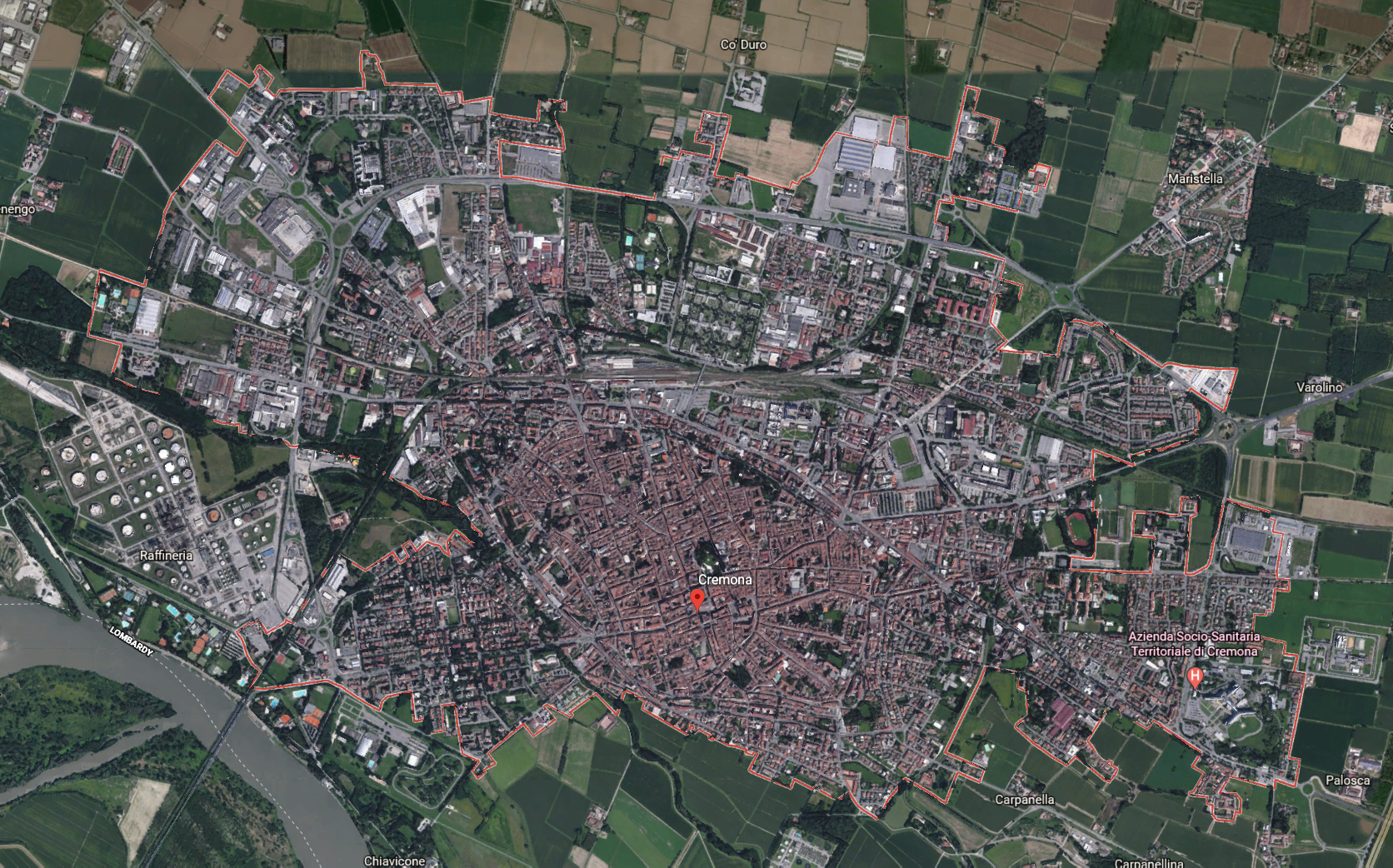
Category: Non-grids

Cremona, Italy

The population of Cremona would agree that the cathedral square is their center. The most important buildings to the city are placed there, like the Romanesque cathedral, the Torrazzo, the octagonal baptistry, the city hall, and the Loggia dei Militi. The city is most famous for its musical history, being the birthplace of Claudio Monteverdi and Antonio Stradivari. It contains The School of Violin and Viola Makers and a museum of antique stringed instruments. Along with its musical influence, Cremona is also a center of agricultural and dairy produce, hosting a market weekly. It manufactures agricultural machinery, silk textiles, bricks, and pianos.

Hyderabad, India

Hyderabad, India is a Southern Indian city, founded in 1591, maintained through the years under two Islamic empires, the British empire, and now independently by the Indian government. The city is spread across 241 square miles, on an elevated terrain, and is surrounded in parts by artificial lakes. The city is unordered, and developed naturally starting from a fortress established in an older part of the city. A lot of the city order developed from individual houses and slums, but since the 2000s, due to a growing middle class, there has been investment in real-estate, leading to large apartment complexes, and gated communities, along with paving better roads by the local municipal corporation. Due to the population, narrow roads, and poor sewage systems, it’s easy to get stuck in traffic for hours, and the transit system (established in 2019) does little to help due to the population. The city is not pedestrian friendly, as sidewalks are largely absent, but due to high-density there is pedestrian traffic, and local knowledge allows people to navigate. Despite its non-grid system, locals find ways to make the disorder in city planning work, and their lives go on.

Cape Coral, FL

Cape Coral, FL

Cape Coral is a city of 200,000 in southwest Florida. The city perfectly illustrates that there is not necessarily a perfect dichotomy between “grid” and “non-grid” patterns, as the “irregular” loops, canals, and curved roads that are decidedly non-grid elements are still imposed upon a grid-like network of large thoroughfares. One thing that Cape Coral shows is that it is not the regularity or irregularity with which an area is planned that inherently leads to density and good land use. In some sense, the city mimics the urban pattern of the Islamic world, featuring minimal public space, dead-end streets around which housing is oriented, and regularity of the external appearances of dwellings. That said, this development differs from that settlement pattern by being built at a vehicular scale, meaning that much space is wasted. Perhaps the greatest oversight in the planning of Cape Coral is cross-access between multiple points. The canals segregate large parts of the city, requiring use of the hierarchical road system to navigate from one area to another, which stands in sharp contrast to other “organically” developed non-grid cities and medieval city cores. Cape Coral suggests, then, that without careful attention to road layout, artificially mimicking non-grid patterns is a poor idea.

Seoul, South Korea

Seoul, a huge metropolis of almost 10 million people, is a conglomeration of old and new neighborhoods, with some built on a grid and a majority that were not. Although Seoul is nearly 2000 years old, little of its modern facade dates back more than a few decades, as the majority of the city was developed very quickly in the decades following the Korean War. However, the layout of the streets still retain some influence from both the Joseon era and the Japanese colonial era. Around 600 of Seoul’s streets originate from the Joseon period, following the natural geography of the city’s streams and resulting in curvilinear, non-gridded streets; the process of dividing the city into districts started under Japanese rule. The new neighborhoods built after the war were a result of prioritizing speed over a uniform urban design for the city. As a result, some individual neighborhoods like Gangnam and Yeouido, were planned carefully, but the majority were not.

Dharavi, Mumbai, India

Dharavi, Mumbai in India is a locality with over 1M people over 2.1 square kilometers. It is a very high density slum, composed of migrants from within the city and rural villages seeking economic opportunity. Due to its high speed of growth and density, much of the housing and small scale factories are haphazardly arranged, making for narrow streets without an arterial road or sanitation network. This type of slum growth represents one form of the city as an organism, being designed by the thousands of residents on the ground instead of a centralized authority. Despite the lack of a grid network, houses are aligned with each other on an angular level, with large angular shifts being wasteful of space. This creates a wave-life flow of the buildings with respect to urban landmarks such as railroads and major roads.

Leiden, Netherlands

Leiden is a city in the province of South Holland, Netherlands that is an agglomeration of four suburbs. Located on the Oude Rijn delta, Leiden was formed on an artificial hill at the convergence of two rivers, the Old and New Rhine. A water town, or grachtenstad, Leiden was built on land reclaimed from bodies of water, so it has a non-uniform layout. Because the land was divided by the measure of bodies of water and joining of suburbs, the boundaries were fixed in relation to natural features and yield “organic” patterns and divisions. Specifically, the city is intersected by numerous small canals with tree-bordered quays. Like most water towns, the canal-streets were kept narrow and building blocks are long and narrow, surrounded by more canals around the area that limit expansion. Strategic fortifications for Leiden were thoughtfully planned around the city’s irregular streets, such as the circular tower castle de Burcht that was built on an earthen mound at the junction of the two rivers.

Boston, Massachussets

Boston is often referred to as a city of neighborhoods because of the abundance of diversely populated neighborhood districts within the city. This is largely due to most of Boston’s current land area not existing when the city was founded. Instead, it was gradually and naturally created without forming a grid and was built around forestry and other natural obstacles. While this lack of centralized planning did cause housing issues in the 19th century and promoted the growth of slums and sprawl, the city planners of Boston have made great efforts to combat this and ultimately turned these challenges into opportunities to restructure and improve the city.

Rabat Medina, Rabat, Morocco

The medina of Rabat is the old city originally established in the 1100s as a citadel and fortress across the river from Salé, or Slaa. It was built as a fortress from which to defend and launch attacks against Iberia. We can see this clearly in the Kasbah of the Udayas, the actual fortress just north of the medina. It’s hard to tell exactly what the town was established for beyond that–i.e., whether the intended residents were just soldiers, or also merchants and other residents. The medina looks a little bit like a grid since most of the streets are straight, but about half of the smaller streets end in dead ends. As Kostof described, the medina is divided up into sections based on general trade: the main street of the market is used for miscellaneous goods, mostly factory-made, and the sections that break off are for trades like pottery, painting, sewing, and food.

Marrakesh, Morocco

Marrakech represents a unique blend of organic patterns influenced by Islamic social law and the changing realities of economics and geopolitics.  The ancient medina is built to serve basic familial and community functions prescribed by Islamic teachings, with the labyrinthine layout following a premodern focus on “neighborhood” and gradual expansion that contributed to the stability of the settlement.  Following colonization, the blueprint for future districts was created using many of the French’s non-grid principles that arose in the 1800s.  Amidst the city’s current shift towards tourism, developers have planned curvilinear roads to support leisure golf communities marketed towards affluent Westerners.

Honolulu, Hawaii

Honolulu, Hawaii, is not on a strict compass point grid system, but the city planners try to incorporate as much grid design as possible. The street system conforms to its large shorelines, valleys, and mountainous terrain that consists of many twists and turns. Someone unfamiliar with Honolulu may have difficulty getting around, but there are major arterial roads and the terminology people use is based on large landmarks that are easy to find. For instance, directions in Honolulu often use terms such as “mauka” and “makai” which mean toward the mountain and toward the sea, respectively. Honolulu is known for its bad traffic, so they developed more major highways to accommodate it; but, with its mountainous ranges, water’s edge, and lava bedrock, it is extremely difficult to achieve a grid system.

Le Mirail, Toulouse, France

Le Mirail is a suburb of the French city of Toulouse that was developed in the 1960s. The suburb’s development follows the principles of Team X, a group of young Modernists who emphasized the organic nature of cities. This focus on organic development is seen in the suburb’s hexagonal network and branching cul-de-sacs connected by a web of human pathways and greenery. The suburb’s layout is an explicit rejection of the grid in exchange for a more egalitarian and “natural” cityscape. However, Le Mirail faced significant funding shortages and was never fully completed, which ironically rendered the suburb isolated and disjointed. Although designed for a diverse socioeconomic populace, today, it is one of the poorest areas of Toulouse with a high unemployment rate and a large immigrant population.

Groznjan, Croatia

Groznjan is a small town on the top of a terraced hill in Croatia. It was established by Romans as a fort kastel due to its high vantage point. As even the town’s inside terrain is very leveled, the initial Roman plan had to adjust to local topography, sacrificing the usually strict grid pattern. Groznjan often changed its rulers and inhabitants, yet it is uniform in style: its medieval urban complex built by Venetians in the 13th century remained largely untouched, and as the town is so small, each renovation took on the scope of the whole city. Recently, the town started attracting more residents due to its contemporary jazz educational programs, and new houses and public spaces grew outside the original kastel walls in an organic pattern along the roads leading up to Groznjan.

Rovaniemi, Finland

Alvar Aalto’s plan for Rovaniemi, imposed on the natural topography, was designed to be in the shape of a reindeer, with the main roads mapping to its antlers and the stadium its eye. Although the zoning aspects of Aalto’s modernist plan for Rovaniemi were never fully realized, they were supposed to have been organized around the antler-inspired, irregular, non-gridded streets. This design decision might be critiqued on similar grounds to Krostof’s commentary on “organic” cities: its hierarchical treatment of city functions might be read as a rejection of continuous growth.

Hampton Roads Region, Virginia

The Hampton Roads Region of Virginia has been an important site for the U.S. armed forces since the War of 1812. There are now a number of bases for the various branches of the military. The spiderweb pattern of roads, centered on the city of Norfolk, was designed to be able to transport supplies and troops from any direction.

Dubai, United Arab Emirates

Dubai is car and oil-based, evident in the the layout of wide roads and highways that run semi-orthogonally throughout the city. The car is honored (to prove it, the city maintains an exotic supercar fleet for its police force). Dubai is attempting to position itself as the city of the future, but its car dependence (and traffic problems) are more reminiscent of the post World War II era.

Grammichele, Sicily

Grammichele is an Italian city of about 15,000 people located in Sicily. The highly rationalized hexagonal city plan is defined in six equal sections, one of which was left for the founder, Prince Carlo María Carafa – passionate about Astronomy and Mathematics – to build his palaces.

Theme: Overlay by Kaira