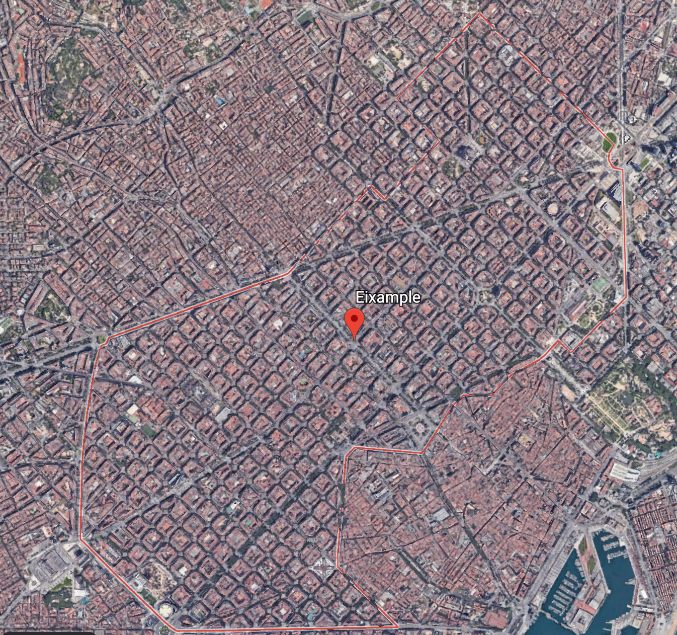
Category: Grids

Beijing, China

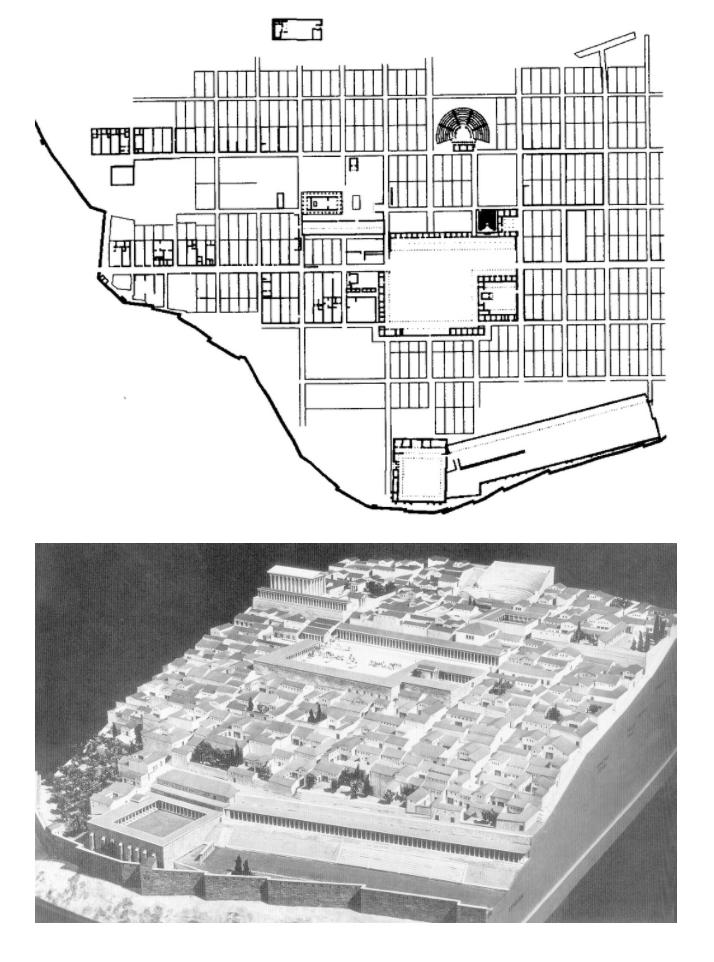
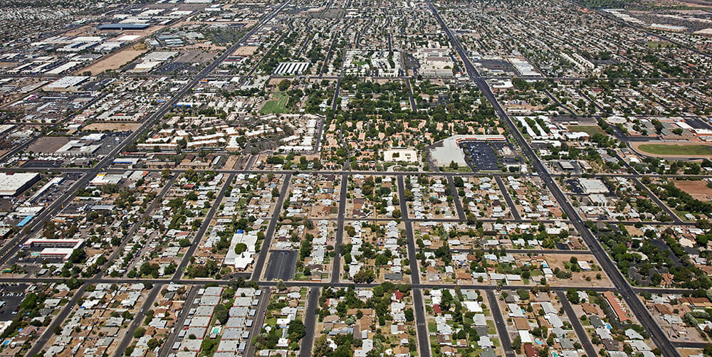
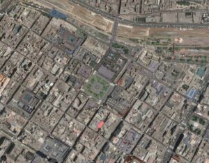
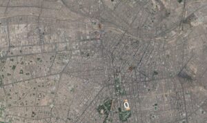
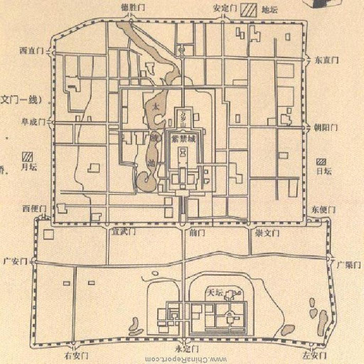
The city design within the Beijing city wall follows a grid pattern. The horizontal running road (Chang An road) and the vertical positioned Forbidden palace forms natural separations between the four quadrants of Beijing. Within each quadrant, roads run along the city gates, further dividing each quadrant into grids. The design of households in Beijing also contributed to the grid pattern in Beijing. Houses in Beijing are typically in rectangular or square forms, this also contributes to the networks of grids. However, roads between houses and neighborhood are typically narrow and irregular, in order to compensate for the different sizes of houses in the area. This makes it easier to getting disoriented in Beijing.

Priene, Ancient Greece

Priene is an Ancient Greek city. It is believed to be the pinnacle of the Greek grid city planning. Its closed-grid structure reveals main the ideals of the Greek grid, which became a popular tool in founding colonies. Firstly, as victorious Greeks brought democracy to the conquered lands, they established towns with lots of equal sizes: Priene consisted of bigger public spaces and 80 equal blocks with 5 private houses each. Secondly, Greeks were focused on occupying strategically important locations that provided good viewability and protection: Priene was built on the slope of the Mycale mountain and overviewed a port of the Aegean Sea. The combination of the steep slope and the gridiron plan provided great visibility of the port and the city itself.

Phoenix, Arizona

Phoenix, Arizona, founded in 1867 by farmers, is contained within a grid structure on flat terrain. Each main road in Phoenix is spaced out by one mile, adjusting for curvature of the Earth. North-south streets are numbered, east-west streets are named, and ‘Central Avenue’ equally divides the North and South parts of the city. Unlike Calthorpe’s ideas for grid design, Phoenix is a largely auto-dependent city as large parts of Phoenix are not accessible by transit, and is also, despite its sunny weather allowing solar panels, a city that is behind on sustainability, and has a shrinking fresh water supply. As Phoenix expands, sustainability and urban sprawl remain problems, and the grid system despite its logical separation, isn’t adaptable enough to fix its problems.

Lima, Peru

Lima, Peru

The capital of Peru and the largest city in the country by far, Lima has seen over 500 years of urbanization built off of the original Spanish colonial pattern. Lima’s original nine squares can be seen abutting the Rimac river, featuring all the standard attributes of a Spanish colonial town plan. But the latest satellite imagery shows that this grid hasn’t been extended perfectly, there’s substantial grid deformation as one gets farther from the original center. This is an excellent example of a grid, featuring planned regularity and some organic attributes to keep it interesting. Moreover, while access to the “center” isn’t as easily achieved as in say Chicago, the center of the city has sort of grown in size to match the needs of the local residents, distributing function rather than relocating, which adds to the coherence of the grid.

Sacramento, United States

Sacramento’s central grid was first planned in the mid-1800s, shortly after the first discoveries of gold. Anticipating that Sacramento would become a huge source of revenue, John Sutter, Jr. asked his planners to develop the city on a grid so that he could organize his land and economic holdings as simply as possible. As such, Sacramento’s central grid was not planned to further any particular conception of the ideal city, but solely for Sutter’s own speculative goals.

Image Source: Google Earth, Library of Congress (https://www.loc.gov/item/2018588053/)

New Haven, Connecticut

New Haven, Connecticut, founded by the English Puritans, was laid in a grid known as the Nine Square Plan – eight squares of 25 acres each arranged around an open public marketplace at its center. The central square forms a dual cross axis of streets defining the edge of the square, with perimeter streets in a 4×4 layout. New Haven’s model was unique among the New England colonies, having been inspired by the orderly, contained aspects of ancient Greek and Roman military camps. The increase in automobile traffic and suburban growth led to street extension, grid deformation, and block manipulation, which gave rise to an orthoradial grid. New Haven was a good attempt at a planned grid city, but it grew in a way that lost the intended right square grid design.

San Francisco, CA

A closed grid plan by physical nature, San Francisco was imposed on a city of hills built on the end of a peninsula, the topographic features limiting opportunities for expansion. The city had a small area, but the grid pattern of the streets and the hills divided the cities into separate portions and valleys. In 1839, Jean-Jacques Vioget, a Swiss-born engineer, planned a grid map following typical Spanish patterns with 12 blocks and a central plaza. Today, this plan lies in the Financial District near Montgomery Street and Montgomery Street. With the increasing flux of residents due to the Gold Rush, San Francisco had trouble balancing density and accessibility. To address these concerns, San Francisco’s block plans were laid out orthogonally the public transportation system was implemented in cable cars, to reduce the commute time for people and make navigation and orientation a lot easier.

Philadelphia, Pennslyvania

Philadelphia is one of the first grid cities implemented in the US, paving the way for other grid cities to emerge. It has “axial avenues and straight-forward grid” (Grant 226), and when created was formed to have the grid covering a limited area, with the outside land being clearly defined. All of the quadrants in the city were originally designed with a common center space which today are now famous garden squares. Philadelphia today continues to be driven by this grid system, with even streets named in methodical ways to make living easier. In this case, the grid system proved very adaptable to the city.

Eixample, Barcelona

The Eixample is a district within the city of Barcelona. It was designed by Catalonian urban planner lldefons Cerda and is characterized by its long streets and a grid pattern intersected by wide avenues that allow for increased visibility and ventilation. This gives The Eixample an increased sense of “openness”— which is unique among other grid patterns. The Eixample was planned to incorporate the needs of its residents and its design called for schools and commercial areas such as markets to be situated every few blocks— many of which still exist in the same locations today. While the Eixample in recent years has become crowded and loud— it remains one of the most popular areas of Barcelona and The Eixample’s basic design has proven to be incredibly adaptable to a modern environment.

Manhattan, New York City

Manhattan’s grid pattern was a response to the population growth between 1790 and 1810. Public health issues increased as a result so some action was needed. It focused on the downtown areas because most of the city’s population lived there. Its main goal was to be structured but flexible. It took about 60 years for the grid to be built up to 155th street, during which many factors (administration, aesthetic values, interest groups) changed and could have undermined the plan. It caused a debate among New Yorkers (property owners in particular). More than 720 buildings were demolished or moved, which caused the city to lose most of its original architectural history.

Nouakchott, Mauritania

Nouakchott is the capital of Mauritania, which between its construction in 1955 and the present has grown from 15,000 inhabitants to roughly 2 million.  Designed by French administrators, Nouakchott’s grid embodies many of the principles of their colonial utility in a pre-capitalist setting.  Population growth brought on by desertification saw planning of new districts favor the order this creates, both on a pure functional and political level.  As the city continues to deal with rapid growth, slavery, terrorism, and autocracy, this layout seems to both exacerbate and control issues – while clearly embodying the repressive hierarchy of the society it serves.

Kentlands, MD

As mentioned in Jill Grant’s article, Kentlands, MD was built in 1988 under the rubric of New Urbanism. Grant describes it as one of the towns that was built on a modified grid that was supposed to diffuse authority. It was developed outside of a major downtown area (D.C.) to be a planned neighborhood for mixed income levels, which is typical of a suburb, but it also contains more multi-family buildings than many suburbs. Project Reference File’s case study of Kentlands reports: “The system is made up of main streets, which are boulevards with parking as well as trees on both sides; primary streets, with parking and trees on both sides; and secondary streets, with parking on one side and trees on the other. There are no culs-de-sac.” There are also small parks throughout the city, and small, artificial lakes. In the northwest corner are grocery stores, and the main street contains live-work buildings along with other commercial businesses.

Aigues-Mortes, France

Aigues-Mortes, located in the Occitanie administrative region of France, is a medieval bastide town. It was designed with a grid pattern inspired by a feature of the Roman system — a castrum. There are two principal roads, one running from the south to the north and one running from the east to the west, that intersect at a central square, borrowing from, as Busquets, Keller, and Yang note, the logic of a military camp. The grid pattern here can be read as closed and pre-capitalist in Marcuse’s sense: its medieval walls, which are preserved, place a physical limit on its extent. Today, because the medieval walls were preserved, the spatial pattern within the walls is discontinuous from the spatial pattern beyond it.

Barcelona

The iconic octagonal grid of L’Eixample was motivated by industrial era urban-inflow and the rising nationalism of the city’s elites, who hoped to build a suitable capital for the Catalan region. The grid’s chamfered corners open up sightlines and provide community space around intersections, giving L’Eixample an airiness not found in standard gridirons.

La Plata, Argentina

La Plata, founded in 1882, is one of the last examples of a city designed (loosely) according to the Law of the Indies, which established a simple, orderly model for new developments in Spain’s colonial holdings. The goal was order, rationality, centrality, and legibility. Gridded streets centered around a church and other governmental buildings, all surrounded by agricultural land (ejido). It has an ortho-radial grid, with “implicit” block subdivision from the diagonal streets, and grid deformation on the outskirts with street extensions. Finally, a ring road surrounds the city for a degree of discrete separation. The city is precisely and intentionally designed, with the grandeur of a planned capital, and it is known for being pedestrian friendly. However, the blocks themselves are very heterogeneous, with unordered jumbles of buildings, some with an inner courtyard that is only accessible through building back entrances. 

New Orleans

New Orleans features a grid pattern that adjusts to the contours of the Mississippi River. The city has retained elements of French urban planning (public squares, wide boulevards, French architecture) that connect it to its French roots.

Theme: Overlay by Kaira