Author: Lynn Chong

Seoullo & Cheonggyecheon

In Seoul, Korea, Seoullo (2017) and Cheonggyecheon (2005) have transformed highway infrastructure into public space. Both projects penetrate some of the most congested neighborhoods in Seoul. Seoullo is an elevated linear park that was once an overpass; Cheonggyecheon was a natural stream covered by a highway.

Bogalusa

Bogalusa, Louisiana is a company town built by the Great Southern Lumber Company in 1902. It serves as an example of how company towns worked to alter the social and civic lives of their employees at a very basic level – by controlling where and how they lived, not just where they worked.

Hampton Roads Region, Virginia

The Hampton Roads Region of Virginia has been an important site for the U.S. armed forces since the War of 1812. There are now a number of bases for the various branches of the military. The spiderweb pattern of roads, centered on the city of Norfolk, was designed to be able to transport supplies and troops from any direction.

Dubai, United Arab Emirates

Dubai is car and oil-based, evident in the the layout of wide roads and highways that run semi-orthogonally throughout the city. The car is honored (to prove it, the city maintains an exotic supercar fleet for its police force). Dubai is attempting to position itself as the city of the future, but its car dependence (and traffic problems) are more reminiscent of the post World War II era.

Old West Durham, North Carolina

Old West Durham, formerly known as Hayti, is a typical example of the negative effects of urban renewal on African-American neighborhoods. In 1957, the North Carolina General Assembly approved a bill to build the Durham Freeway, a large highway that ran directly through the neighborhood. Not only did the plan cost millions of dollars and take over 14 years, but it displaced more than 4,000 and irreparably destroyed the commercial viability and social cohesiveness of an entire community. Today, the Hayti area remains one of the most economically neglected and exploited areas in all of Durham.

Bucharest Civic Center

Built in the 1980s under the regime of Nicolae Ceausescu, Bucharest’s Civic Center is a massive socialist-realist corridor of apartment blocks and tree-lined sidewalks meant to convey the awesome power of Socialist Romania. Ceausescu was inspired by his 1971 trip to North Korea, where he was impressed with the development under Kim-il Sung and his Juche ideology.

Empire State Plaza (Albany, NY)

In creating the Empire State Plaza in Albany, NY (1965-1976), an emboldened state used eminent domain to uproot 7,000 residents and create a large-scale campus featuring brutalist concrete towers that centralized the state’s bureaucracy. The campus represents the aggressive strong-handed attitudes of NYS politics at the time.

Pyongyang, North Korea

The city plan of Pyongyang, the capital of North Korea, is representative of the Kim family’s Juche ideology of extreme authority and control. In the 1960s, the city’s smaller, polycentric spaces were combined into one central area to accommodate displays of military might.

Grammichele, Sicily

Grammichele is an Italian city of about 15,000 people located in Sicily. The highly rationalized hexagonal city plan is defined in six equal sections, one of which was left for the founder, Prince Carlo María Carafa – passionate about Astronomy and Mathematics – to build his palaces.

Barcelona

The iconic octagonal grid of L’Eixample was motivated by industrial era urban-inflow and the rising nationalism of the city’s elites, who hoped to build a suitable capital for the Catalan region. The grid’s chamfered corners open up sightlines and provide community space around intersections, giving L’Eixample an airiness not found in standard gridirons.

La Plata, Argentina

La Plata, founded in 1882, is one of the last examples of a city designed (loosely) according to the Law of the Indies, which established a simple, orderly model for new developments in Spain’s colonial holdings. The goal was order, rationality, centrality, and legibility. Gridded streets centered around a church and other governmental buildings, all surrounded by agricultural land (ejido). It has an ortho-radial grid, with “implicit” block subdivision from the diagonal streets, and grid deformation on the outskirts with street extensions. Finally, a ring road surrounds the city for a degree of discrete separation. The city is precisely and intentionally designed, with the grandeur of a planned capital, and it is known for being pedestrian friendly. However, the blocks themselves are very heterogeneous, with unordered jumbles of buildings, some with an inner courtyard that is only accessible through building back entrances. 

New Orleans

New Orleans features a grid pattern that adjusts to the contours of the Mississippi River. The city has retained elements of French urban planning (public squares, wide boulevards, French architecture) that connect it to its French roots.

World Trade Center

The original WTC superblock marked the end of Robert Moses-era urban planning where whole neighborhoods were demolished to make room for monumental public works. It came to symbolize American dominance in the global economy, and in its destruction and rebuilding, it continues to symbolize strength, resilience, and power.

Chandigarh –– A Symbol of Modernity and Independence

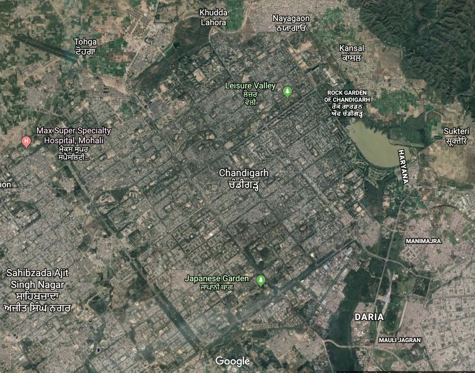
Chandigarh, whose construction began in 1952, is a built example of a city with a gridiron plan. Interestingly, the arrangement of this plan, divided into 47 self-contained micro neighborhoods, is justified by means of human analogy — for example, Sector 17, the central business district, is likened to the heart and Sector 1, the Capitol Complex, to the head. Chandigarh, in this sense, appears to have not only been a statement economic project for post-independence India but also an unrestrictive lab for Le Corbusier’s theories of the urban. India’s first prime minister, Jawaharlal Nehru, wanted Chandigarh to become a monumental city symbolizing India’s bright future of modernity, progress, and independence, but its segmentation into cells based on neighborhood units became a symbol of class segregation. 

Colonía Federal, Mexico City, Mexico

The design of Colonía Federal is based on post-revolutionary rationalist ideology. The neighborhood’s radiating octagonal pattern is reminiscent of Palmanova, Italy, a city highly symbolic of Renaissance-era rationality and order. Here, order is applied to housing for workers.

Angkor Thom, Cambodia

Angkor Thom demonstrates an urban layout with a religious/spiritual component fundamental to its creation. The centrally located Bayon/temple signifies Mount Meru–the home of the gods–and stands higher and grander than everything else, which is in accordance to their cosmic belief in the gods inhabiting the universe. The city was surrounded by walls and moat with axial gates at the four cardinal directions, with common people living in dense villages outside of the temple complex, and coming into the complex to pay tribute.

Nowa Huta, Kraków, Poland

The Nowa Huta district of Kraków, Poland is a planned “socialist realist” district with symbolic significance as a proletariat paradise. The large steel mill was especially symbolic, built although there was very little local demand for steel and a lack of iron ore or coal deposits anywhere close.

Saint Petersburg

St Petersburg employed baroque urbanism with its radial boulevards, but unlike Versailles, the Royal Palace is not the focal point. Instead, the Admiralty Complex is found at the most prominent intersection, speaking to the fact that St. Petersburg was a project for the glorification of Russia.

Theme: Overlay by Kaira