Author: Alexander Cui

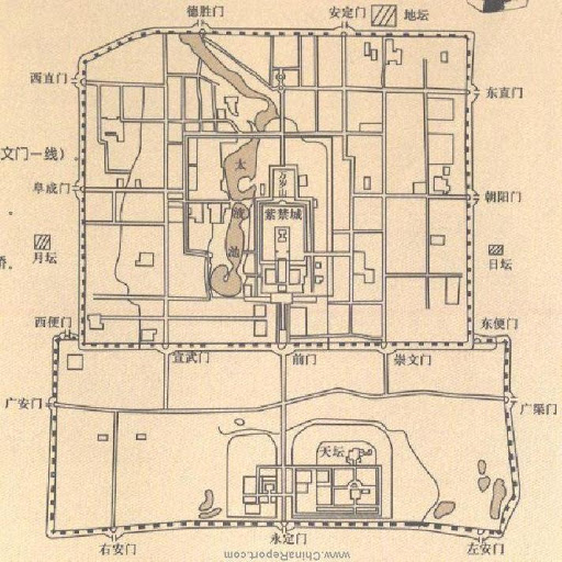
Dharavi, Mumbai, India

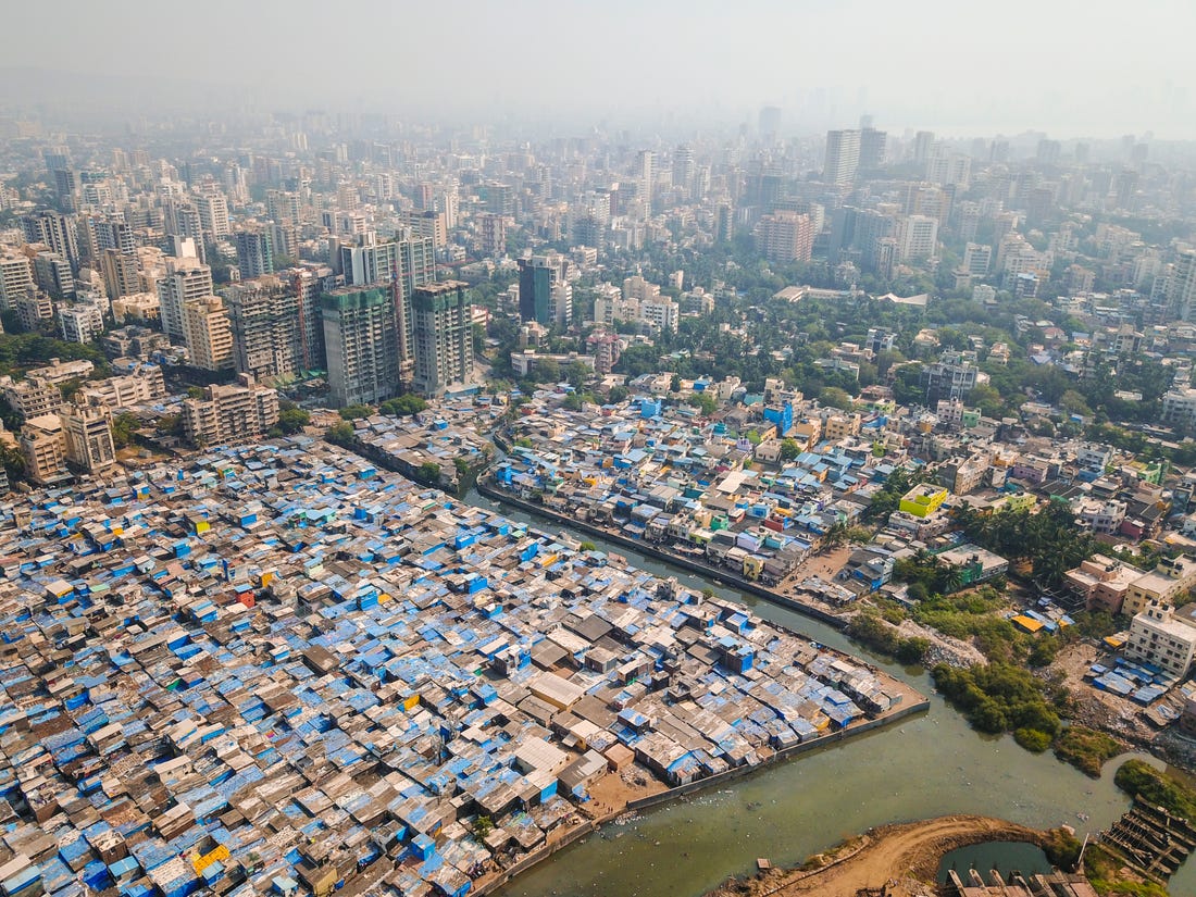
Dharavi, Mumbai in India is a locality with over 1M people over 2.1 square kilometers. It is a very high density slum, composed of migrants from within the city and rural villages seeking economic opportunity. Due to its high speed of growth and density, much of the housing and small scale factories are haphazardly arranged, making for narrow streets without an arterial road or sanitation network. This type of slum growth represents one form of the city as an organism, being designed by the thousands of residents on the ground instead of a centralized authority. Despite the lack of a grid network, houses are aligned with each other on an angular level, with large angular shifts being wasteful of space. This creates a wave-life flow of the buildings with respect to urban landmarks such as railroads and major roads.

Leiden, Netherlands

Leiden is a city in the province of South Holland, Netherlands that is an agglomeration of four suburbs. Located on the Oude Rijn delta, Leiden was formed on an artificial hill at the convergence of two rivers, the Old and New Rhine. A water town, or grachtenstad, Leiden was built on land reclaimed from bodies of water, so it has a non-uniform layout. Because the land was divided by the measure of bodies of water and joining of suburbs, the boundaries were fixed in relation to natural features and yield “organic” patterns and divisions. Specifically, the city is intersected by numerous small canals with tree-bordered quays. Like most water towns, the canal-streets were kept narrow and building blocks are long and narrow, surrounded by more canals around the area that limit expansion. Strategic fortifications for Leiden were thoughtfully planned around the city’s irregular streets, such as the circular tower castle de Burcht that was built on an earthen mound at the junction of the two rivers.

Boston, Massachussets

Boston is often referred to as a city of neighborhoods because of the abundance of diversely populated neighborhood districts within the city. This is largely due to most of Boston’s current land area not existing when the city was founded. Instead, it was gradually and naturally created without forming a grid and was built around forestry and other natural obstacles. While this lack of centralized planning did cause housing issues in the 19th century and promoted the growth of slums and sprawl, the city planners of Boston have made great efforts to combat this and ultimately turned these challenges into opportunities to restructure and improve the city.

Rabat Medina, Rabat, Morocco

The medina of Rabat is the old city originally established in the 1100s as a citadel and fortress across the river from Salé, or Slaa. It was built as a fortress from which to defend and launch attacks against Iberia. We can see this clearly in the Kasbah of the Udayas, the actual fortress just north of the medina. It’s hard to tell exactly what the town was established for beyond that–i.e., whether the intended residents were just soldiers, or also merchants and other residents. The medina looks a little bit like a grid since most of the streets are straight, but about half of the smaller streets end in dead ends. As Kostof described, the medina is divided up into sections based on general trade: the main street of the market is used for miscellaneous goods, mostly factory-made, and the sections that break off are for trades like pottery, painting, sewing, and food.

Marrakesh, Morocco

Marrakech represents a unique blend of organic patterns influenced by Islamic social law and the changing realities of economics and geopolitics.  The ancient medina is built to serve basic familial and community functions prescribed by Islamic teachings, with the labyrinthine layout following a premodern focus on “neighborhood” and gradual expansion that contributed to the stability of the settlement.  Following colonization, the blueprint for future districts was created using many of the French’s non-grid principles that arose in the 1800s.  Amidst the city’s current shift towards tourism, developers have planned curvilinear roads to support leisure golf communities marketed towards affluent Westerners.

Honolulu, Hawaii

Honolulu, Hawaii, is not on a strict compass point grid system, but the city planners try to incorporate as much grid design as possible. The street system conforms to its large shorelines, valleys, and mountainous terrain that consists of many twists and turns. Someone unfamiliar with Honolulu may have difficulty getting around, but there are major arterial roads and the terminology people use is based on large landmarks that are easy to find. For instance, directions in Honolulu often use terms such as “mauka” and “makai” which mean toward the mountain and toward the sea, respectively. Honolulu is known for its bad traffic, so they developed more major highways to accommodate it; but, with its mountainous ranges, water’s edge, and lava bedrock, it is extremely difficult to achieve a grid system.

Le Mirail, Toulouse, France

Le Mirail is a suburb of the French city of Toulouse that was developed in the 1960s. The suburb’s development follows the principles of Team X, a group of young Modernists who emphasized the organic nature of cities. This focus on organic development is seen in the suburb’s hexagonal network and branching cul-de-sacs connected by a web of human pathways and greenery. The suburb’s layout is an explicit rejection of the grid in exchange for a more egalitarian and “natural” cityscape. However, Le Mirail faced significant funding shortages and was never fully completed, which ironically rendered the suburb isolated and disjointed. Although designed for a diverse socioeconomic populace, today, it is one of the poorest areas of Toulouse with a high unemployment rate and a large immigrant population.

Groznjan, Croatia

Groznjan is a small town on the top of a terraced hill in Croatia. It was established by Romans as a fort kastel due to its high vantage point. As even the town’s inside terrain is very leveled, the initial Roman plan had to adjust to local topography, sacrificing the usually strict grid pattern. Groznjan often changed its rulers and inhabitants, yet it is uniform in style: its medieval urban complex built by Venetians in the 13th century remained largely untouched, and as the town is so small, each renovation took on the scope of the whole city. Recently, the town started attracting more residents due to its contemporary jazz educational programs, and new houses and public spaces grew outside the original kastel walls in an organic pattern along the roads leading up to Groznjan.

Rovaniemi, Finland

Alvar Aalto’s plan for Rovaniemi, imposed on the natural topography, was designed to be in the shape of a reindeer, with the main roads mapping to its antlers and the stadium its eye. Although the zoning aspects of Aalto’s modernist plan for Rovaniemi were never fully realized, they were supposed to have been organized around the antler-inspired, irregular, non-gridded streets. This design decision might be critiqued on similar grounds to Krostof’s commentary on “organic” cities: its hierarchical treatment of city functions might be read as a rejection of continuous growth.

Beijing, China

The city design within the Beijing city wall follows a grid pattern. The horizontal running road (Chang An road) and the vertical positioned Forbidden palace forms natural separations between the four quadrants of Beijing. Within each quadrant, roads run along the city gates, further dividing each quadrant into grids. The design of households in Beijing also contributed to the grid pattern in Beijing. Houses in Beijing are typically in rectangular or square forms, this also contributes to the networks of grids. However, roads between houses and neighborhood are typically narrow and irregular, in order to compensate for the different sizes of houses in the area. This makes it easier to getting disoriented in Beijing.

Priene, Ancient Greece

Priene is an Ancient Greek city. It is believed to be the pinnacle of the Greek grid city planning. Its closed-grid structure reveals main the ideals of the Greek grid, which became a popular tool in founding colonies. Firstly, as victorious Greeks brought democracy to the conquered lands, they established towns with lots of equal sizes: Priene consisted of bigger public spaces and 80 equal blocks with 5 private houses each. Secondly, Greeks were focused on occupying strategically important locations that provided good viewability and protection: Priene was built on the slope of the Mycale mountain and overviewed a port of the Aegean Sea. The combination of the steep slope and the gridiron plan provided great visibility of the port and the city itself.

Phoenix, Arizona

Phoenix, Arizona, founded in 1867 by farmers, is contained within a grid structure on flat terrain. Each main road in Phoenix is spaced out by one mile, adjusting for curvature of the Earth. North-south streets are numbered, east-west streets are named, and ‘Central Avenue’ equally divides the North and South parts of the city. Unlike Calthorpe’s ideas for grid design, Phoenix is a largely auto-dependent city as large parts of Phoenix are not accessible by transit, and is also, despite its sunny weather allowing solar panels, a city that is behind on sustainability, and has a shrinking fresh water supply. As Phoenix expands, sustainability and urban sprawl remain problems, and the grid system despite its logical separation, isn’t adaptable enough to fix its problems.

Sacramento, United States

Sacramento’s central grid was first planned in the mid-1800s, shortly after the first discoveries of gold. Anticipating that Sacramento would become a huge source of revenue, John Sutter, Jr. asked his planners to develop the city on a grid so that he could organize his land and economic holdings as simply as possible. As such, Sacramento’s central grid was not planned to further any particular conception of the ideal city, but solely for Sutter’s own speculative goals.

Image Source: Google Earth, Library of Congress (https://www.loc.gov/item/2018588053/)

New Haven, Connecticut

New Haven, Connecticut, founded by the English Puritans, was laid in a grid known as the Nine Square Plan – eight squares of 25 acres each arranged around an open public marketplace at its center. The central square forms a dual cross axis of streets defining the edge of the square, with perimeter streets in a 4×4 layout. New Haven’s model was unique among the New England colonies, having been inspired by the orderly, contained aspects of ancient Greek and Roman military camps. The increase in automobile traffic and suburban growth led to street extension, grid deformation, and block manipulation, which gave rise to an orthoradial grid. New Haven was a good attempt at a planned grid city, but it grew in a way that lost the intended right square grid design.

San Francisco, CA

A closed grid plan by physical nature, San Francisco was imposed on a city of hills built on the end of a peninsula, the topographic features limiting opportunities for expansion. The city had a small area, but the grid pattern of the streets and the hills divided the cities into separate portions and valleys. In 1839, Jean-Jacques Vioget, a Swiss-born engineer, planned a grid map following typical Spanish patterns with 12 blocks and a central plaza. Today, this plan lies in the Financial District near Montgomery Street and Montgomery Street. With the increasing flux of residents due to the Gold Rush, San Francisco had trouble balancing density and accessibility. To address these concerns, San Francisco’s block plans were laid out orthogonally the public transportation system was implemented in cable cars, to reduce the commute time for people and make navigation and orientation a lot easier.

Philadelphia, Pennslyvania

Philadelphia is one of the first grid cities implemented in the US, paving the way for other grid cities to emerge. It has “axial avenues and straight-forward grid” (Grant 226), and when created was formed to have the grid covering a limited area, with the outside land being clearly defined. All of the quadrants in the city were originally designed with a common center space which today are now famous garden squares. Philadelphia today continues to be driven by this grid system, with even streets named in methodical ways to make living easier. In this case, the grid system proved very adaptable to the city.

Eixample, Barcelona

The Eixample is a district within the city of Barcelona. It was designed by Catalonian urban planner lldefons Cerda and is characterized by its long streets and a grid pattern intersected by wide avenues that allow for increased visibility and ventilation. This gives The Eixample an increased sense of “openness”— which is unique among other grid patterns. The Eixample was planned to incorporate the needs of its residents and its design called for schools and commercial areas such as markets to be situated every few blocks— many of which still exist in the same locations today. While the Eixample in recent years has become crowded and loud— it remains one of the most popular areas of Barcelona and The Eixample’s basic design has proven to be incredibly adaptable to a modern environment.

Nouakchott, Mauritania

Nouakchott is the capital of Mauritania, which between its construction in 1955 and the present has grown from 15,000 inhabitants to roughly 2 million.  Designed by French administrators, Nouakchott’s grid embodies many of the principles of their colonial utility in a pre-capitalist setting.  Population growth brought on by desertification saw planning of new districts favor the order this creates, both on a pure functional and political level.  As the city continues to deal with rapid growth, slavery, terrorism, and autocracy, this layout seems to both exacerbate and control issues – while clearly embodying the repressive hierarchy of the society it serves.

Kentlands, MD

As mentioned in Jill Grant’s article, Kentlands, MD was built in 1988 under the rubric of New Urbanism. Grant describes it as one of the towns that was built on a modified grid that was supposed to diffuse authority. It was developed outside of a major downtown area (D.C.) to be a planned neighborhood for mixed income levels, which is typical of a suburb, but it also contains more multi-family buildings than many suburbs. Project Reference File’s case study of Kentlands reports: “The system is made up of main streets, which are boulevards with parking as well as trees on both sides; primary streets, with parking and trees on both sides; and secondary streets, with parking on one side and trees on the other. There are no culs-de-sac.” There are also small parks throughout the city, and small, artificial lakes. In the northwest corner are grocery stores, and the main street contains live-work buildings along with other commercial businesses.

Aigues-Mortes, France

Aigues-Mortes, located in the Occitanie administrative region of France, is a medieval bastide town. It was designed with a grid pattern inspired by a feature of the Roman system — a castrum. There are two principal roads, one running from the south to the north and one running from the east to the west, that intersect at a central square, borrowing from, as Busquets, Keller, and Yang note, the logic of a military camp. The grid pattern here can be read as closed and pre-capitalist in Marcuse’s sense: its medieval walls, which are preserved, place a physical limit on its extent. Today, because the medieval walls were preserved, the spatial pattern within the walls is discontinuous from the spatial pattern beyond it.

Sverdlovsk-45, Russia

Sverdlovsk-45 is one of the USSR’s closed towns build in 1948 for the purpose of top-secret scientific research. Unlike most of the post-soviet spaces, the plan of the city is extremely simple half-circle, as it had to be rapidly erected by Stalin’s orders: to build a city around a uranium-enrichment facility that can be easily and quickly navigated by the researchers. As all the research was super confidential, extreme surveillance was easier to maintain in a town with a basic structure of wide radial roads leading to one open point – the public embarkment. Moreover, the town is completely surrounded by vast forests and a river, limiting access to unsupervised exit and entry.

Priestwood, Bracknell, England

Priestwood is a neighborhood unit of Bracknell, one of the 10 British new towns built in the 1940s after World War II. Planned for a size of 287 acres and a population of 7800 residents, with a primary school at the center and an eponymous avenue serving as a boundary, it hewed very closely to Clarence Perry’s original concept. Although Bracknell has undergone substantial redevelopment, the original neighborhood units have been preserved, with redevelopment focused on the city center. However, the redevelopment has accentuated one of the criticisms of the neighborhood unit concept: Priestwood is now both aesthetically and functionally isolated from the rest of the town.

the Mission District, San Francisco, California

The Mission distinct is a prominent neighborhood in San Francisco, California. It is relatively large, at 1.5 square miles and 45,000 residents. Before the 1940s, the neighborhood was largely composed of Irish and German immigrant workers in the working class. In the 1940s to 1960s, many Mexican immigrants were forced to move due to the construction of the Bay Bridge, and settled in the area, while led to white flight and the modern Mission’s Chicano/Latino character. Starting in the 1960s, the LGBTQ population in the Mission grew to be one of the most visible in the US. To me, the MIssion is a really fascinating example of a community that carries a huge amount of cultural and socio-economic diversity, while being united in an identity of alternativeness while the MIssion as their refuge. That concentration of cultures has led to the mission being an epicentre for arts, music, food and festivals. Between 1967-1973, the Mission Coalition Organization (MCO), a multi-issue community organization, also formed in the model set by Saul Alinsky. While the group split apart, it involved 20% of the 50,000 residents at its peak and left many neighborhood organizations that operate to this day, showing the potential of strong neighborhood identity coupled with active representation.

Baldwin Hills, Los Angeles

Baldwin Hills, Los Angeles, is a famous planned neighborhood unit by Clarence Stein, a pioneer in the application of Clarence Perry’s principles. Stein implemented a confined -known boundary- insular 80-acre super block with innovative, spacious, light-filled condominium units and plenty of green space that gives Baldwin Hills a distinct image. He prioritized pedestrian walkways within the public space, thus there are no major roads or highways that pass through, but there is nearby public transportation. The major streets bound the outskirts of the neighborhood, while Baldwin Hills itself has schools, malls, and family recreational activities that help it to form a sense of community and opportunities for residents to be active in the neighborhood.

Kanda, Tokyo, Japan

Kanda is a high-density, mixed-building neighborhood in Tokyo, Japan that is characterized by universities, residential areas, shrines and commercial centers like Akhibara, a famous electronics and anime hub. Kanda was built using the Japanese idea of ‘machi’, or neighborhood, and has a unique identity due to the high population of students and its electronics culture. Kanda is embedded within Tokyo, and like Perry’s original plans for neighborhood units, contains access to socialization, nature and civic services within walking distance, along with its own neighborhood identity and civic spaces in its bounded quadrilateral space. Where it differs from Perry’s ideas, and many neighborhood units in the West, is its density, its heterogenous building types, and the placement of roads instead of a community center at the center of the neighborhood. Kanda demonstrates the idea of a successfully adapted neighborhood unit integrated into a populated city, bringing a sense of community and convenience to an urban setting.

Theme: Overlay by Kaira