Author: Luke Morris

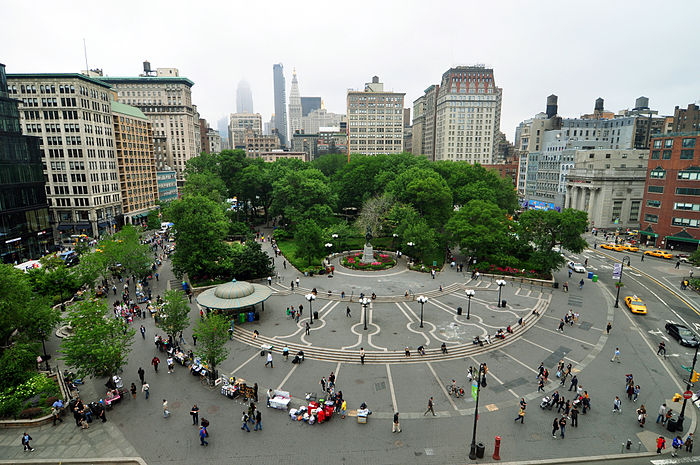
Union Square Park, New York City

Union Square Park in New York City was built in 1839 and has served for nearly two centuries as a gathering place for the residents of downtown Manhattan. The form of Union Square is such that it can be used for many different purposes— for commerce, for entertainment, for political events/rallies, and for recreational uses. The park is intersected by many paths that are bordered by pockets of green, vegetated areas— a style that was inspired by London’s residential squares. The design of the park emphasizes its oval shape with a walkway circumnavigating the park, and a large statue within its center. As downtown New York has evolved, Union Square Park has served and existed for its community. While it has undergone many changes over the course of its history, Union Square has become an integral aspect of the culture of New York— the grounds of which have frequently been used as a focal point for protests, political rallies/events, public meetings, and rap battles. While it is often criticized for attracting a large homeless population— in many ways, this only further serves to demonstrate how the Park exists to serve the wide range of cultures, ethnicities, and socioeconomic backgrounds of New York City.

Hinokicho Park, Tokyo, Japan

Hinokicho Park is located in midtown Tokyo, a well-developed area consisting of commercial building, premium high raise apartment and office buildings in addition to the 21-21 design sight museum. The area has a unique mix of Japanese traditions, modernity, art and fashion. The cherry trees along the perimeters of the space separate the park from the outside world, in a both physical and spiritual way.

Jewish Ghetto in Venice

The Venetian Ghetto was a segregated section of northern Venice where Jewish people in Venice were forced to reside, and return to by a nightly curfew starting at 1560. It is the origin of the term “ghetto” that is used to describe other segregated, slum-like areas predominantly occupied by minorities today. Venice was a medieval city notable for its functional zoning, and decentralized neighborhood clusters revolving around public squares.

The Campo di Ghetto Nuovo centered the Jewish Ghetto, where up to 5000 Jews from Italy, Germany, France, Spain and the former Ottoman Empire both maintained their own synagogues all with entrances to the square. This also created a unique opportunity for cultural exchange, and an example of the potential for the medieval Jewish Diaspora communities.

Around the square and elsewhere, the ghetto stacked up to 9 floors because of overcrowding, making them able to view the rest of the city from above. In 1560, the Venetian Board of Trade required Jews to barricade any windows and doors that overlooked the canals.

Some critics would point to the Jewish Ghetto as an example of the risks of planning overly restrictive “urban villages” that contain rather than connect its inhabitants for these reasons above.


https://www.huffpost.com/entry/urbanism-and-the-venetian-ghetto_b_855908
https://www.jewishbookcouncil.org/book/the-jewish-ghetto-and-the-visual-imagination-of-early-modern-venice

Yama, Moscow

“Yama” (Russian for “the pit”) is a folk name given to a public amphitheater structure built around a part of Moscow’s old fortress wall. Planned as a historical open-air site in one of the liveliest parts of the city center, the pit became very likened and populated by young citizens. While monumental parks and public spaces, the Red Square, the Kremlin often feels like a fake-ish tourist attraction to Russian metropolitans, “Yama” organically became a true Muscovite’s place: people came here to socialize, listen to independent lectures and free music concerts, and most importantly – openly drink. In Russia, it is illegal to drink alcohol in public spaces, so usually, people would drink sneakily, get very intoxicated, and cause social disturbances. However, “Yama” became a morally different region of the city center – what was prohibited elsewhere, became more a limited (people would only drink a little), yet normal practice in the amphitheater. I think it is very interesting how this small civic place became a zone where the common law is ignored both by citizens and the police (it is situated right next to a police station), due to Moscow’s demand for a place where people could drink a bit and not worry about getting caught.

Piazza Maggiore, Bologna, Italy

Built in medieval Bologna during the 13th century, the Piazza Maggiore is an example of the ideal medieval city square, and it remains one of the most important civic spaces in modern Bologna. The piazza is located at the geographic center of Bologna, and it is well-connected to the surrounding areas, with multiple roads and walkways branching out of the square for easy pedestrian access. It is also adjacent to the smaller Piazza del Nattuno, another central gathering space. Today, the piazza features both important civic buildings and monuments, from the centuries-old Basilica of San Petronio to the central pedestrian platform, which was built less than 100 years ago.

Image Source: https://commons.wikimedia.org/wiki/File:Piazza_maggiore_115.jpg

Zócalo, Mexico City, Mexico

Zócalo, is the main city square in Mexico City, and first began as a gathering place for religious rites and commercial purposes during the Aztec times, in what used to be called Tenochtitlan. After its conquest, Alonso Garcia Bravo tore down most of the Aztec temples and pyramids, and built buildings for the empire’s symbolic significance like the Metropolitan Cathedral, Palacio Nacional, and marketplaces. Over the years, Zócalo became a space for several historic events such as Grito de Dolores, and the 1828 Parián Riot for Mexican Independence. Today, after efforts to revitalize the area, Zócalo has become a space for parades and cultural events like the Festival de México, and it has continued to host political gatherings and protests. Zócalo is a space that has been transformed many times for the ruling power’s purposes , but it has remained a gathering space for civic action, democracy and culture.

Lincoln Road, Miami

Designed by Morris Lapidus in the 1950s, Lincoln Road’s pedestrian corridor became one of the first outdoor malls in America.  The layout and architectural flourishes represent a greater attention towards merging public and commercial spaces that continues to be replicated – arguably through poorly copied town centers.  After a period of decline in the 1970s, Lincoln Road redefined itself as a community hub for artists and young professionals.  However the flexibility of this space has been questioned as it’s catered to tourists over the last few decades.  With the threat of climate change, many now question the site’s long term future.
Image source: https://www.shutterstock.com/video/clip-8901133-aerial-video-lincoln-road-miami-beach-fl

The Lyceum, Alexandria, Virginia

The Lyceum is a small, antebellum building that is home to Alexandria’s city museum. Originally built as a library, the building’s neoclassical style distinguishes itself from nearby row-houses and establishes itself as a major landmark and civic space of Alexandria. The building’s prominence as a civic space is also heightened by its location at the crossroads of two major avenues, Prince Street and George Washington Memorial Parkway, and its location in the center of town. Today, the building continues to serve the public by hosting public programs and exhibitions; the building’s large hall is home to frequent concerts and is rentable by the public. The Lyceum is proof that civic spaces do not need to be large to have a big community impact.

Faneuil Hall

Faneuil Hall was founded in 1742 as a central marketplace for crops and livestock in downtown Boston. As England attempted to enforce taxes on the colonies, it emerged as an important meeting place in the late 1700s, as well as providing storage space for the American military. In 1825, it expanded to Quincy, North, and South markets, which include restaurants, bars, and shops selling a variety of merchandise, collectively now known as Faneuil Hall Marketplace. Today, it is still considered Boston’s central meeting place that offers tourists and residents a historical urban marketplace with unique shops, restaurants, and outdoor entertainment.

Jefferson Square Park

Jefferson Square Park in Louisville, KY was built in the 1970s, replacing what was called the “Center Building.” It sits across from the District Court, the Circuit Court, City Hall, and the County Clerk, some of which were built as early as the 1870s. It looks most like Andres Duany’s “Double Axial Square,” though it does not contain any buildings, because of the central circle and the paths that jut out from it. It is supposed to serve the same general function as the agora or the forum–a central place where people can congregate, especially because it sits in front of buildings that hold symbolic and practical weight. There have been many kinds of public political events there, from gatherings to commemorate fallen firefighters and policemen, to protests against the city and the police department for the killing of Breonna Taylor. It is in part because of these more recent protests that I chose this square: it has become a central fixture in Louisville that it hadn’t been beforehand, a now vital space that draws and captures attention.

National Mall

The National Mall is a park that spans the area between the Lincoln Memorial and the United States Capitol grounds, including the Washington Monument. Several museums, art galleries and other monumental art surrounds an open lawn.

Interestingly, this open lawn has become a forum and civic ground of sorts, hosting several notable protests and rallies, such as the Vietnam War Moratorium Rally and MLK’s “I Have a Dream” speech. However, it wasn’t always like this – prior to the 20th century, the National Mall was largely Victorian-era gardens with a web of paths. Senator James McMillan, heavily influenced by the City Beautiful movement. There was a desire to beautify the capital in DC, along with the poor architecture and public spaces. After touring Europe’s great buildings and landscapes, they decided to clear out the existing mall, allowing for the construction of neoclassical civic institutions and the central lawn, which followed the City Beautiful ideas of creating moral and civic virtue by embedding monumental design into the city and life of citizenry.

Hudson Yards

Hudson Yards in New York City is a real state development that was completed in 2019. It is an area within the larger city that contains a public green space, office buildings, a mall, and cultural facilities. The goal of the Hudson Yards was to create a new monumental cultural center within Manhattan and it prides itself on being the new economic, culinary, and social center of New York—symbolizing the city’s modernity and technological innovation. This is symbolized principally by The “Vessel”, a permanent interactive art installation that represents the goals and technological prowess of the Hudson Yards. However, while these goals are admirable, there have been many critics of Hudson Yards that argue that it only caters to New York’s wealthier residents and that it has not properly integrated itself properly into the city but rather exists as its own separate entity that does not reflect New York City as a whole.

VDNH, Moscow, Russia

VDNH (abbreviation for Exhibition of Achievement of National Economy) is a permanent exhibition site in Moscow that had the purpose of showing and trading different achievements of Soviet workers. VDNH consists of a huge park and 60 Stalinist style, triumphant art-deco pavilions, some of which are dedicated to the Soviet nations, and others to different industrial sectors and sciences. Each year VDNH hosted an exhibition of the achievements of simple workers: from astrophysicists to farmers. VDNH is a unique monumental public space that showcased the greatness of the USSR as a whole, but also the accomplishments of its smaller nations, groups, and individuals.

Tiananmen Square, Beijing China

Tiannanmen Square, one of the most well know monumental location and tourist attraction in China locates right in the heart of Beijing in front of the gates of Tiannanmen. During the imperial times, Tiananmen Square was commonly used as public spaces for local residents in addition to a gathering place for demonstrations and protests. The square currently houses the Monument to the People’s Heroes and the Mausoleum of Mao Zedong. When walking in the square, people are surrounding by key government structures, creating a sense of power and order. Builds around the square are grand yet not over whelming, creating a sense of pride through its architecture languages.

Golden Gate Bridge, San Francisco, CA

The fires following the San Francisco earthquake of April 1906 provided a blank slate for City Beautiful planning. But unlike in other major US cities, the elegant city Burnham proposed never came to light, as a rapid rebuilding undermined the process. However, elements of the plan were executed later, such as tying transportation to scenic vistas, specifically with the Golden Gate Bridge. 

A work of art, an engineering marvel, and an American icon, the suspension spans the distance between San Francisco and Marin counties. A classic interconnection of the forms of the open paradigm, San Francisco’s natural resources were carefully managed, with the bridge is flanked on both ends by the Golden Gate National Park, which was connected to the Civic Center planned by Burnham. From the multi-lane boulevard to the monumental urban greenery surrounded by dense building, the Golden Gate Bridge’s construction and waterfront parks were typical of defining public spaces of the time. Besides its practical use in opening communications between city districts, the bridge was also beautifying and become the most internationally recognized symbols of the city. 

Gateway Arch, St. Louis, United States

The Gateway Arch, dedicated to American westward expansion, is the tallest monument in the United States. Architect Eero Sarinen envisioned the arch as a modern extension of the landscape, rising from the bank of the Mississippi River to frame the rest of St. Louis and, symbolically, the western United States. Perhaps more importantly, planners saw the project as a way to revitalize and “beautify” St. Louis. As with many other urban renewal projects, constructors bulldozed hundreds of old buildings, erased the original city grid, and displaced thousands of residents, leading to local opposition. Today, the arch is an architectural icon and a tourist attraction, but it hasn’t led to a real revitalization of the city.

Image Source: https://www.flickr.com/photos/132084522@N05/17275578342/

The Champs-Élysées

The Champs-Élysées in Paris were created as an entrance to Paris from the countryside to signify entering a “powerful monarch” capital city. Its importance at this time was less than in today’s world, sitting as a formality back then, but today being one of the best models for the 2nd Empire’s street typologies and sections. It further evolved into a formalization of nature, with rows of trees showing the King’s ability to be orderly. Today, the Champs-Élysées are one of the most famous avenues, known for its shopping, Arc de Triomphe among other monuments and cultural significance.

Gateway of India, Mumbai, India

The Gateway of India was constructed by the British Empire in the 20th century, to commemorate the visit of King George V and Queen Mary to Mumbai, then known as Bombay. The arch is 26 metres high with four turrets, and the style of architecture is Indo-Saracenic, with some Islamic and Marathi influence. The Gateway originally served as a symbolic entrance to important British personnel, and in 1948, is where the last British troops left India. Today, it serves as a tourist destination and a local gathering spot, with several street vendors, and ferries leading from it to the Arabian Sea. The Gateway of India is a relic of a colonized India, that has now been adapted into the landscape of a quickly developing free India.

Capitol Complex, Chandigarh, India

Chandigarh’s Capitol Complex, whose plan and buildings were designed by Le Corbusier, is located at the northernmost point of the city and today houses the administrative bodies of both Haryana and Punjab. The monumental, symbolic architecture interspersed throughout, including the Open Hand monument (a sign of “peace and reconciliation” according to Le Corbusier), captures the optimism of Nehru and post-independence India, monumentalizing a break from the imperial tradition of city making that occurred prior. The image, depicting the Open Hand monument, gives a sense of their scale.

Ringstrasse, Vienna, Austria

Ringstrasse is a large boulevard that cuts through the center of Vienna’s historical city center. Created in the 1850s, the boulevard is typical of the “Parisian-style” boulevard, with multi-lane roads, green spaces, and monuments that bookend streets. Formed after the demolition of the city’s old defensive walls, the street is a grand representation of the Austro-Hungarian empire’s commitment to Enlightenment ideals. The street is flanked by important cultural institutions, such as the Parliament and the Vienna Opera House, in a neo-renaissance style that calls back to Greco-Roman and Renaissance traditions of ideal rationalism and scientific thought. Ringstrasse is emblematic of the power of the Hapsburg dynasty and a monument to Vienna’s cultural heritage and its status as a modern city. Today, the boulevard continues to be a symbol of Vienna and is an important public space for locals.

Haymarket vs. I-65 in Louisville, KY

In the mid-20th century, Louisville, KY underwent a period of development and urban renewal. In 1962, plans for the large highway “Interstate 65” cut through the historic, vital farmers’ market called Haymarket near what is now Old Louisville. The market had been a bustling center of urban vitality and economic activity since the 1890s, and had stocked grocery stores and individual citizens’ pantries for decades. When I-65 forced Haymarket to close, the Louisville Urban Renewal Agency sought to preserve it in the form of a “Produce Plaza,” the construction of which required bulldozing all that was left of Haymarket. I-65 was built in Louisville to connect the growing suburbs to the main downtown area, and as part of the national surge in monumentalism and prioritizing highways over internal connectivity.

Manila, Philippines

The plan to transform and modernize Manila, Philippine’s capital city, was composed by Daniel Burnham and Peirce Anderson. They created a capital that focused on national culture and sentiment by geometrically arranging the city around civic centers, tree-lined boulevards, and landscaped spaces. Burnham made a strong effort to keep Manila’s culture in the forefront by leaving historic remains intact. Burnham and Pierce imported neoclassical urbanism to create monumental design projects and forge a new city image to encourage a sense of patriotism. They emphasized how spatial organization, aesthetics, environmental behaviorism and civic politics were entwined within modern American dominance and grand urban design. Manila is a great example of monumentalism that does not entirely sublimate the existing culture rather signifies strength and collectivism.

Guggenheim Bilbao, Spain

The Frank Gehry-designed Guggenheim Bilbao is often regarded as one of the most important structures of the last 50 years.  Opened in 1997, it helped transform the declining port town of Bilbao into a prosperous cultural hub – creating the “Bilbao effect.”  While some have identified it as a key part of the city’s “gentrification,” critics have otherwise lauded it for its respectful placement in the city, positive relationship with the community, and geopolitical impact on Spanish unity.  Given the almost unmitigated success that has made this project a perennial award winner, one wonders if this is actually the Bilbao anomaly?

Hyderabad, India

Hyderabad, India is a Southern Indian city, founded in 1591, maintained through the years under two Islamic empires, the British empire, and now independently by the Indian government. The city is spread across 241 square miles, on an elevated terrain, and is surrounded in parts by artificial lakes. The city is unordered, and developed naturally starting from a fortress established in an older part of the city. A lot of the city order developed from individual houses and slums, but since the 2000s, due to a growing middle class, there has been investment in real-estate, leading to large apartment complexes, and gated communities, along with paving better roads by the local municipal corporation. Due to the population, narrow roads, and poor sewage systems, it’s easy to get stuck in traffic for hours, and the transit system (established in 2019) does little to help due to the population. The city is not pedestrian friendly, as sidewalks are largely absent, but due to high-density there is pedestrian traffic, and local knowledge allows people to navigate. Despite its non-grid system, locals find ways to make the disorder in city planning work, and their lives go on.

Seoul, South Korea

Seoul, a huge metropolis of almost 10 million people, is a conglomeration of old and new neighborhoods, with some built on a grid and a majority that were not. Although Seoul is nearly 2000 years old, little of its modern facade dates back more than a few decades, as the majority of the city was developed very quickly in the decades following the Korean War. However, the layout of the streets still retain some influence from both the Joseon era and the Japanese colonial era. Around 600 of Seoul’s streets originate from the Joseon period, following the natural geography of the city’s streams and resulting in curvilinear, non-gridded streets; the process of dividing the city into districts started under Japanese rule. The new neighborhoods built after the war were a result of prioritizing speed over a uniform urban design for the city. As a result, some individual neighborhoods like Gangnam and Yeouido, were planned carefully, but the majority were not.

Theme: Overlay by Kaira